IMAGES TAKEN NEAR TO
Chute Forest, ANDOVER, SP11 9DH
Introduction
This page details the photographs taken nearby to SP11 9DH by members of the Geograph project.
The Geograph project started in 2005 with the aim of publishing, organising and preserving representative images for every square kilometre of Great Britain, Ireland and the Isle of Man.

There are currently over 7.5m images from over14,400 individuals and you can help contribute to the project by visiting https://www.geograph.org.uk
Image Map
Images are licensed for reuse under creativecommons.org/licenses/by-sa/2.0
Notes
- Clicking on the map will re-center to the selected point.
- The higher the marker number, the further away the image location is from the centre of the postcode.
Image Listing (4 Images Found)
Images are licensed for reuse under creativecommons.org/licenses/by-sa/2.0
Image
Details
Distance
1
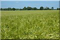
Farmland, Chute Forest
A crop of winter barley just inside Wiltshire and north of the boundary with Hampshire.
Image: © Andrew Smith
Taken: 13 Jun 2021
0.19 miles
2
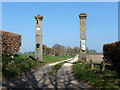
Track to South Lodge
Formerly South Lodge, some way up the track, was at an entrance to the park of Chute Lodge, hence the imposing pillars. This park entrance and indeed much of the park is no more.
Image: © Robin Webster
Taken: 20 Mar 2015
0.20 miles
4
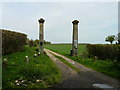
Redenham - Gate To South Lodge
This private road is guarded by these impressive gate pillars.
Image: © Chris Talbot
Taken: 5 May 2008
0.23 miles