IMAGES TAKEN NEAR TO
Goodworth Clatford, ANDOVER, SP11 7HR
Introduction
This page details the photographs taken nearby to SP11 7HR by members of the Geograph project.
The Geograph project started in 2005 with the aim of publishing, organising and preserving representative images for every square kilometre of Great Britain, Ireland and the Isle of Man.

There are currently over 7.5m images from over14,400 individuals and you can help contribute to the project by visiting https://www.geograph.org.uk
Image Map (Loading...)


Getting Data...Please wait
Leaflet Map data © OpenStreetMap
Images are licensed for reuse under creativecommons.org/licenses/by-sa/2.0
Notes
- Clicking on the map will re-center to the selected point.
- The higher the marker number, the further away the image location is from the centre of the postcode.
Image Listing (5 Images Found)
Images are licensed for reuse under creativecommons.org/licenses/by-sa/2.0
Image
Details
Distance
1
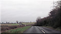
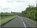
A3057 approaching sewage works
Power lines above gives a positional fix
Image: © John Firth
Taken: 17 Apr 2013
0.14 miles
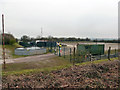
2
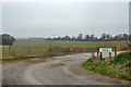
Gated track to oil well
Despite the name, Igas operate an oil well at the end of this track. Unfortunately, no 'nodding donkeys'.
Image: © Robin Webster
Taken: 20 Mar 2015
0.15 miles
4
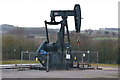
Nodding donkey pump at Goodworth Clatford oil well site
Image: © David Martin
Taken: 14 Jan 2019
0.24 miles
5
Oil well, Goodworth Clatford
The actual well is at the small feature towards the far corner of the compound on the right. For several years there was no 'nodding donkey', as here, but later one was found necessary - see Image
Image: © Robin Webster
Taken: 20 Mar 2015
0.24 miles