IMAGES TAKEN NEAR TO
Eton Dorney Walk, Riverside Close, ANDOVER, SP11 6YL
Introduction
This page details the photographs taken nearby to Eton Dorney Walk, Riverside Close, SP11 6YL by members of the Geograph project.
The Geograph project started in 2005 with the aim of publishing, organising and preserving representative images for every square kilometre of Great Britain, Ireland and the Isle of Man.

There are currently over 7.5m images from over14,400 individuals and you can help contribute to the project by visiting https://www.geograph.org.uk
Image Map
Images are licensed for reuse under creativecommons.org/licenses/by-sa/2.0
Notes
- Clicking on the map will re-center to the selected point.
- The higher the marker number, the further away the image location is from the centre of the postcode.
Image Listing (2 Images Found)
Images are licensed for reuse under creativecommons.org/licenses/by-sa/2.0
Image
Details
Distance
1

Flytipping on the byway
It is amazing how far unwanted stuff gets along quite narrow byways.
Image: © Graham Horn
Taken: 26 Apr 2008
0.05 miles
2
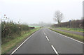
A343 north of Andover
This is the last of the rural 'A' road before it is subsumed by Andover.
Image: © Stuart Logan
Taken: 16 Nov 2011
0.24 miles