IMAGES TAKEN NEAR TO
Longparish, ANDOVER, SP11 6PR
Introduction
This page details the photographs taken nearby to SP11 6PR by members of the Geograph project.
The Geograph project started in 2005 with the aim of publishing, organising and preserving representative images for every square kilometre of Great Britain, Ireland and the Isle of Man.

There are currently over 7.5m images from over14,400 individuals and you can help contribute to the project by visiting https://www.geograph.org.uk
Image Map (Loading...)


Getting Data...Please wait
Leaflet Map data © OpenStreetMap
Images are licensed for reuse under creativecommons.org/licenses/by-sa/2.0
Notes
- Clicking on the map will re-center to the selected point.
- The higher the marker number, the further away the image location is from the centre of the postcode.
Image Listing (51 Images Found)
Images are licensed for reuse under creativecommons.org/licenses/by-sa/2.0
Image
Details
Distance
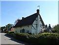
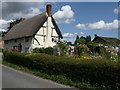
3

Longparish - Thatched Cottage
A fine cottage on the junction of Mill Lane.
Image: © Chris Talbot
Taken: 5 Jul 2009
0.03 miles
5
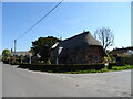
Tudor Cottage, Longparish
Thatched cottage on the B3048.
Image: © JThomas
Taken: 26 Apr 2022
0.04 miles
6
Longparish - An English Country Garden
A typical thatched cottage.
Image: © Chris Talbot
Taken: 5 Jul 2009
0.04 miles
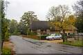
7
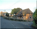
Tudor Cottage
Situated at the B3048 junction with Mill Lane this is a Grade II listed cottage with English Heritage Building ID: 139676. It dates from the 17th C and has 19th & 20th C additions and renovations.
Image: © Stuart Logan
Taken: 14 Feb 2013
0.05 miles
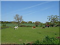
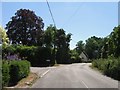
10
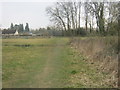
Public footpath to the B3048 at Longparish
Image: © Peter Robinson
Taken: 8 Apr 2013
0.05 miles