IMAGES TAKEN NEAR TO
Andover Down, ANDOVER, SP11 6LP
Introduction
This page details the photographs taken nearby to SP11 6LP by members of the Geograph project.
The Geograph project started in 2005 with the aim of publishing, organising and preserving representative images for every square kilometre of Great Britain, Ireland and the Isle of Man.

There are currently over 7.5m images from over14,400 individuals and you can help contribute to the project by visiting https://www.geograph.org.uk
Image Map (Loading...)


Getting Data...Please wait
Leaflet Map data © OpenStreetMap
Images are licensed for reuse under creativecommons.org/licenses/by-sa/2.0
Notes
- Clicking on the map will re-center to the selected point.
- The higher the marker number, the further away the image location is from the centre of the postcode.
Image Listing (5 Images Found)
Images are licensed for reuse under creativecommons.org/licenses/by-sa/2.0
Image
Details
Distance
1
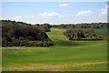
Harewood Forest
This is a view of Harewood Forest looking west towards Image The smudge in the top left of the picture was rather large raptor I think it might have been a buzzard.
Image: © Glyn Baker
Taken: 5 May 2006
0.15 miles
2
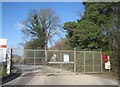
Secure gates
Works depot close to the course of the former Longparish Railway.
Image: © Fernweh
Taken: 10 Mar 2012
0.16 miles
3
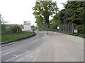
Site entrance on London Road, Hurstbourne Priors
Running along the bed of the old railway line
Image: © David Howard
Taken: 10 May 2015
0.16 miles
5
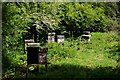
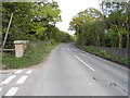
Apiary
This apiary is just off a footpath (recently rededicated as a byway) that runs from the B3400 towards East Aston.
Image: © Glyn Baker
Taken: 5 May 2006
0.20 miles