IMAGES TAKEN NEAR TO
Andover Down, ANDOVER, SP11 6LJ
Introduction
This page details the photographs taken nearby to SP11 6LJ by members of the Geograph project.
The Geograph project started in 2005 with the aim of publishing, organising and preserving representative images for every square kilometre of Great Britain, Ireland and the Isle of Man.

There are currently over 7.5m images from over14,400 individuals and you can help contribute to the project by visiting https://www.geograph.org.uk
Image Map
Images are licensed for reuse under creativecommons.org/licenses/by-sa/2.0
Notes
- Clicking on the map will re-center to the selected point.
- The higher the marker number, the further away the image location is from the centre of the postcode.
Image Listing (10 Images Found)
Images are licensed for reuse under creativecommons.org/licenses/by-sa/2.0
Image
Details
Distance
1
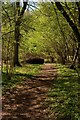
Footpath near Andover Down
This Footpath runs from Andover Down into the Harewood Forest
Image: © Glyn Baker
Taken: 5 May 2006
0.17 miles
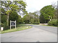
2
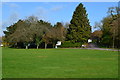
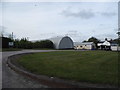
View across grass towards Andover Down Farm
Image: © David Martin
Taken: 11 Nov 2019
0.18 miles
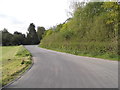
5
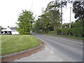
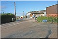
London Road at the entrance to Andover Down Farm
Image: © David Howard
Taken: 10 May 2015
0.20 miles
6
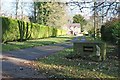
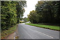
Andover, Hampshire
Oaklands, off the minor road leading south from the B3400 in the south of the square.
Image: © Brendan and Ruth McCartney
Taken: 27 Nov 2011
0.22 miles
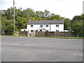
8
Andover, Hampshire
Industrial buildings at Andover Down Farm.
Image: © Brendan and Ruth McCartney
Taken: 27 Nov 2011
0.23 miles