IMAGES TAKEN NEAR TO
Elder Crescent, ANDOVER, SP10 3XZ
Introduction
This page details the photographs taken nearby to Elder Crescent, SP10 3XZ by members of the Geograph project.
The Geograph project started in 2005 with the aim of publishing, organising and preserving representative images for every square kilometre of Great Britain, Ireland and the Isle of Man.

There are currently over 7.5m images from over14,400 individuals and you can help contribute to the project by visiting https://www.geograph.org.uk
Image Map (Loading...)


Getting Data...Please wait
Leaflet Map data © OpenStreetMap
Images are licensed for reuse under creativecommons.org/licenses/by-sa/2.0
Notes
- Clicking on the map will re-center to the selected point.
- The higher the marker number, the further away the image location is from the centre of the postcode.
Image Listing (35 Images Found)
Images are licensed for reuse under creativecommons.org/licenses/by-sa/2.0
Image
Details
Distance
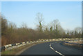
3
Andover Quaker Meeting in the Community Centre
Image: © Michael FORD
Taken: Unknown
0.17 miles
4
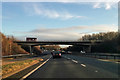
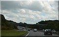
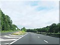
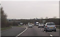
A343 bridge over A303
For the A343 heading south.
Image: © Robin Webster
Taken: 16 Dec 2017
0.20 miles
7
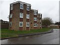
The Hexagon
A block of flats in the shape of hexagons off Salisbury Road. This view is from Hazel Close.
Image: © Oscar Taylor
Taken: 7 Mar 2023
0.21 miles
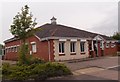
8
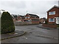
Hazel Close
A road on a small housing estate off the A303.
Image: © Oscar Taylor
Taken: 7 Mar 2023
0.22 miles
10
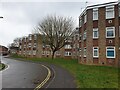
The Hexagon
A block of flats in the shape of hexagons off Salisbury Road. This view is from Hazel Close.
Image: © Oscar Taylor
Taken: 7 Mar 2023
0.22 miles