IMAGES TAKEN NEAR TO
Denning Mead, ANDOVER, SP10 3LN
Introduction
This page details the photographs taken nearby to Denning Mead, SP10 3LN by members of the Geograph project.
The Geograph project started in 2005 with the aim of publishing, organising and preserving representative images for every square kilometre of Great Britain, Ireland and the Isle of Man.

There are currently over 7.5m images from over14,400 individuals and you can help contribute to the project by visiting https://www.geograph.org.uk
Image Map
Images are licensed for reuse under creativecommons.org/licenses/by-sa/2.0
Notes
- Clicking on the map will re-center to the selected point.
- The higher the marker number, the further away the image location is from the centre of the postcode.
Image Listing (22 Images Found)
Images are licensed for reuse under creativecommons.org/licenses/by-sa/2.0
Image
Details
Distance
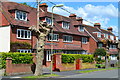
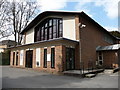
1
Andover - Dennings Mead
Dennings Mead is named after Lord Denning master of the Rolls, who was a local boy.
Image: © Chris Talbot
Taken: 4 Feb 2009
0.09 miles
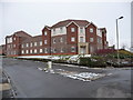
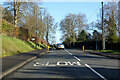
3
Andover - Beach Hurst
Beach Hurst is the Test Valley Councils offices in Andover.
Image: © Chris Talbot
Taken: 4 Feb 2009
0.12 miles
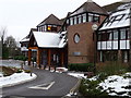
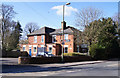
4
Andover - St John the Baptist RC Church
This church is tucked away in a quiet corner of Andover.
Image: © Chris Talbot
Taken: 18 Mar 2009
0.14 miles
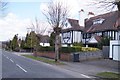
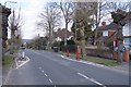
7
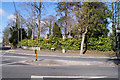
Salisbury Road, Andover
Towards the town centre.
Image: © Robin Webster
Taken: 13 Jan 2023
0.16 miles
9
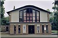
Andover St John the Baptist Roman Catholic Church
Erected in 1958.
Image: © Michael FORD
Taken: Unknown
0.16 miles