IMAGES TAKEN NEAR TO
Silver Birch Road, ANDOVER, SP10 3DT
Introduction
This page details the photographs taken nearby to Silver Birch Road, SP10 3DT by members of the Geograph project.
The Geograph project started in 2005 with the aim of publishing, organising and preserving representative images for every square kilometre of Great Britain, Ireland and the Isle of Man.

There are currently over 7.5m images from over14,400 individuals and you can help contribute to the project by visiting https://www.geograph.org.uk
Image Map
Images are licensed for reuse under creativecommons.org/licenses/by-sa/2.0
Notes
- Clicking on the map will re-center to the selected point.
- The higher the marker number, the further away the image location is from the centre of the postcode.
Image Listing (58 Images Found)
Images are licensed for reuse under creativecommons.org/licenses/by-sa/2.0
Image
Details
Distance
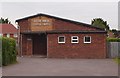
1
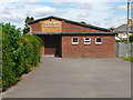
Andover - Gospel Chapel
The Silver Birch Gospel Chapel.
Image: © Chris Talbot
Taken: 22 Aug 2011
0.05 miles
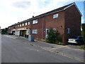
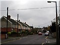
3
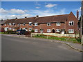
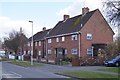
Andover - King George Road
Houses on King George Road
Image: © Chris Talbot
Taken: 22 Aug 2011
0.08 miles
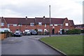
4
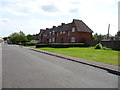
Andover - King George Road
Housing on King George Road
Image: © Chris Talbot
Taken: 22 Aug 2011
0.08 miles
5
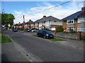
Andover - Ferndale Road
Housing on Ferndale Road.
Image: © Chris Talbot
Taken: 22 Aug 2011
0.10 miles
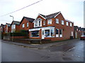
6
Andover - Convenence Store
Convenence Store on Ferndale Road.
Image: © Chris Talbot
Taken: 22 Aug 2011
0.10 miles
7
Mylen Road, Andover
Mylen Road heads in a south-southwestly direction.
Image: © Peter Jordan
Taken: 15 Nov 2006
0.12 miles
8
Andover - Challis Tackle
Challis Tackle has long been a mecca for the local fishermen.
Image: © Chris Talbot
Taken: 16 Nov 2009
0.12 miles