IMAGES TAKEN NEAR TO
SO5 5JN
Introduction
This page details the photographs taken nearby to SO5 5JN by members of the Geograph project.
The Geograph project started in 2005 with the aim of publishing, organising and preserving representative images for every square kilometre of Great Britain, Ireland and the Isle of Man.

There are currently over 7.5m images from over14,400 individuals and you can help contribute to the project by visiting https://www.geograph.org.uk
Image Map
Images are licensed for reuse under creativecommons.org/licenses/by-sa/2.0
Notes
- Clicking on the map will re-center to the selected point.
- The higher the marker number, the further away the image location is from the centre of the postcode.
Image Listing (164 Images Found)
Images are licensed for reuse under creativecommons.org/licenses/by-sa/2.0
Image
Details
Distance
1
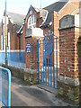
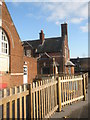
Gate entrance at Norwood Primary School
Image: © Basher Eyre
Taken: 12 Dec 2009
0.02 miles
2
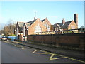
Norwood Primary School in the weak winter sunshine
Image: © Basher Eyre
Taken: 12 Dec 2009
0.02 miles
3
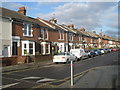
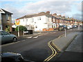
Houses at the top end of Chamberlayne Road
Image: © Basher Eyre
Taken: 12 Dec 2009
0.03 miles
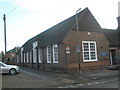
5
The Prism Centre
Taken in Chamberlayne Road.
Image: © Basher Eyre
Taken: 12 Dec 2009
0.04 miles
6
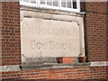
Sign for a former incarnation of Norwood Primary School
Image: © Basher Eyre
Taken: 12 Dec 2009
0.05 miles
7
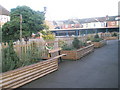
Seats in the playground at Norwood Primary School
Image: © Basher Eyre
Taken: 12 Dec 2009
0.05 miles
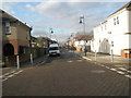
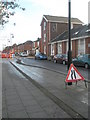
9
Approaching the junction of Factory Road and Chamberlayne Road
Image: © Basher Eyre
Taken: 12 Dec 2009
0.06 miles
10
Norwood Primary School in Chamberlayne Road
Image: © Basher Eyre
Taken: 12 Dec 2009
0.07 miles