IMAGES TAKEN NEAR TO
SO5 3JD
Introduction
This page details the photographs taken nearby to SO5 3JD by members of the Geograph project.
The Geograph project started in 2005 with the aim of publishing, organising and preserving representative images for every square kilometre of Great Britain, Ireland and the Isle of Man.

There are currently over 7.5m images from over14,400 individuals and you can help contribute to the project by visiting https://www.geograph.org.uk
Image Map
Images are licensed for reuse under creativecommons.org/licenses/by-sa/2.0
Notes
- Clicking on the map will re-center to the selected point.
- The higher the marker number, the further away the image location is from the centre of the postcode.
Image Listing (40 Images Found)
Images are licensed for reuse under creativecommons.org/licenses/by-sa/2.0
Image
Details
Distance
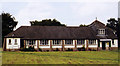
2
St Francis Church Hall, Nightingale Avenue
Basher Eyre (http://www.geograph.org.uk/profile/17822 ) tells me that this is a community-orientated church which has links with the nearby Nightingale Primary school.
Image: © Peter Facey
Taken: 3 Jul 2010
0.05 miles
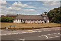
3
St Francis, Nightingale Avenue, Eastleigh
Image: © Basher Eyre
Taken: 1 Jul 2011
0.05 miles
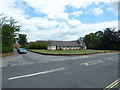
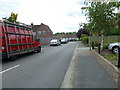
4
Looking from Nightingale Avenue into Heron Square
Image: © Basher Eyre
Taken: 1 Jul 2011
0.06 miles
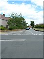
5
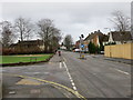
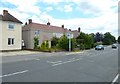
Nightingale Avenue in Eastleigh
Looking eastward from Heron Square.
Image: © Peter Wood
Taken: 26 Feb 2017
0.07 miles
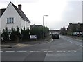
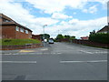
6
Approaching the junction of Wren Road and Nightingale Avenue
Image: © Basher Eyre
Taken: 1 Jul 2011
0.08 miles
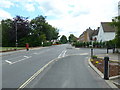
8
Looking down Wren Road towards Falcon Square
Image: © Basher Eyre
Taken: 1 Jul 2011
0.10 miles
10
Looking from Nightingale Avenue into Woodpecker Way (eastern end)
Image: © Basher Eyre
Taken: 1 Jul 2011
0.12 miles