IMAGES TAKEN NEAR TO
Hiltingbury Road, EASTLEIGH, SO53 5NS
Introduction
This page details the photographs taken nearby to Hiltingbury Road, SO53 5NS by members of the Geograph project.
The Geograph project started in 2005 with the aim of publishing, organising and preserving representative images for every square kilometre of Great Britain, Ireland and the Isle of Man.

There are currently over 7.5m images from over14,400 individuals and you can help contribute to the project by visiting https://www.geograph.org.uk
Image Map
Images are licensed for reuse under creativecommons.org/licenses/by-sa/2.0
Notes
- Clicking on the map will re-center to the selected point.
- The higher the marker number, the further away the image location is from the centre of the postcode.
Image Listing (6 Images Found)
Images are licensed for reuse under creativecommons.org/licenses/by-sa/2.0
Image
Details
Distance
1
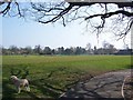
Hiltingbury Park
Hiltingbury pavilion on right hand side of photo.
Image: © Robin Baker
Taken: 9 Apr 2007
0.09 miles
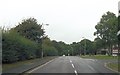
2
Nichol Road, Hiltingbury, Chandler's Ford
Looking north.
Image: © Robin Webster
Taken: 13 Feb 2017
0.12 miles
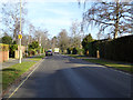
3
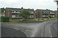
Junction of Ashdown Road and Charnwood Crescent
Streetscape in Chandler's Ford
Image: © peter clayton
Taken: 21 Dec 2008
0.17 miles
4
Ashdown Road entrance from Hiltingbury Road
Image: © John Firth
Taken: 19 Sep 2013
0.18 miles
5
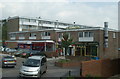
Shopping centre, Hiltingbury
Shops in Ashdown Road
Image: © Pierre Terre
Taken: 28 Jun 2006
0.21 miles
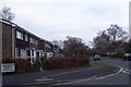
6
Ashdown Road
Not all of Hiltingbury consists of large detached houses -these maisonettes are at the corner of Ashdown Road and Richmond Close
Image: © Pierre Terre
Taken: 28 Jun 2006
0.21 miles