IMAGES TAKEN NEAR TO
Woodlands Close, EASTLEIGH, SO53 5AT
Introduction
This page details the photographs taken nearby to Woodlands Close, SO53 5AT by members of the Geograph project.
The Geograph project started in 2005 with the aim of publishing, organising and preserving representative images for every square kilometre of Great Britain, Ireland and the Isle of Man.

There are currently over 7.5m images from over14,400 individuals and you can help contribute to the project by visiting https://www.geograph.org.uk
Image Map
Images are licensed for reuse under creativecommons.org/licenses/by-sa/2.0
Notes
- Clicking on the map will re-center to the selected point.
- The higher the marker number, the further away the image location is from the centre of the postcode.
Image Listing (8 Images Found)
Images are licensed for reuse under creativecommons.org/licenses/by-sa/2.0
Image
Details
Distance
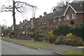
1
Woodlands Close in Chandler's Ford
Houses in this Cul-de-Sac have interesting round windows
Image: © peter clayton
Taken: 1 Mar 2009
0.04 miles
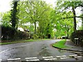
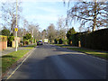
2
Nichol Road
Typical houses in Hiltingbury
Image: © Pierre Terre
Taken: 20 Mar 2006
0.12 miles
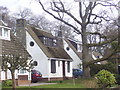
3
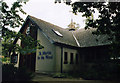
St Martin in the Wood, Chandlers Ford
Built in 1960.
Image: © Michael FORD
Taken: Unknown
0.13 miles
4
Nichol Road, Hiltingbury, Chandler's Ford
Looking north.
Image: © Robin Webster
Taken: 13 Feb 2017
0.20 miles
5
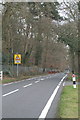
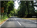
Hocombe Road
This road runs along the north of the suburban area of Hiltingbury with the countryside of Cranbury Park to the north.
Image: © Pierre Terre
Taken: 20 Mar 2006
0.21 miles
6
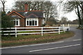
Home Farm Gatehouse
The entrance to Home Farm from Hocombe Road
Image: © Pierre Terre
Taken: 20 Mar 2006
0.21 miles