IMAGES TAKEN NEAR TO
Station Lane, EASTLEIGH, SO53 4DW
Introduction
This page details the photographs taken nearby to Station Lane, SO53 4DW by members of the Geograph project.
The Geograph project started in 2005 with the aim of publishing, organising and preserving representative images for every square kilometre of Great Britain, Ireland and the Isle of Man.

There are currently over 7.5m images from over14,400 individuals and you can help contribute to the project by visiting https://www.geograph.org.uk
Image Map
Images are licensed for reuse under creativecommons.org/licenses/by-sa/2.0
Notes
- Clicking on the map will re-center to the selected point.
- The higher the marker number, the further away the image location is from the centre of the postcode.
Image Listing (142 Images Found)
Images are licensed for reuse under creativecommons.org/licenses/by-sa/2.0
Image
Details
Distance
1
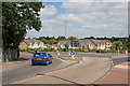
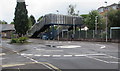
Roundabout on B3043, Chandler's Ford
Joining Bournemouth, Hursley and Winchester roads.
Image: © Peter Facey
Taken: 28 Jun 2008
0.01 miles
2
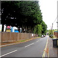
Down Station Lane, Chandler's Ford
From School Lane, Station Lane descends towards Chandler's Ford railway station.
Image: © Jaggery
Taken: 26 Jul 2017
0.02 miles
3
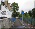
Footpath and cycleway to Chandler's Ford railway station
Descending from Bournemouth Road past Chandler's Ford Chinese Medical Centre.
Image: © Jaggery
Taken: 26 Jul 2017
0.03 miles
4
The Arch building and sculpture, Station Lane, Chandler's Ford
The building is the home of Centrestage Productions Youth Theatre.
See https://www.geograph.org.uk/photo/5625525 for a closer view of the sculpture and some details.
Image: © Jaggery
Taken: 26 Jul 2017
0.03 miles
5
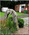
The Arch, Station Lane, Chandler's Ford
A nearby information plaque records that The Arch was designed and sculpted by Paul Sivell following discussions with CPYT (Centrestage Productions Youth Theatre) members. It embodies aspects of performance-related subjects and their application to young people.
Image: © Jaggery
Taken: 26 Jul 2017
0.03 miles
6
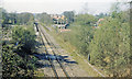
Chandler's Ford station (remains), 1984
View NW, towards Romsey and Salisbury: ex-LSWR Eastleigh - Romsey - Salisbury/Andover line. In the past it had been quite a busy line, especially for freight, but by 1984 is reduced to a single-line running only through to Salisbury, Romsey - Andover Junction having closed from 7/9/64. Chandlers Ford station was closed from 5/5/69, but as the area became increasingly populated, a new station was built, opening on 19/10/03, and a local service was re-introduced from Romsey - Eastleigh - Southampton.
Image: © Ben Brooksbank
Taken: 23 Apr 1984
0.03 miles
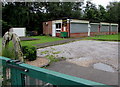
7
Station Lane mini-roundabout, Chandler's Ford
On the approach to Chandler's Ford railway station.
Image: © Jaggery
Taken: 26 Jul 2017
0.04 miles
8
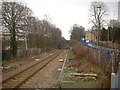
View from the end of the platform towards Eastleigh
This railway line from Eastleigh to Romsey was closed to passenger trains many years ago but has recently re-opened.
Image: © ANDY FISH
Taken: 20 Feb 2007
0.05 miles
9
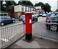
King George VI pillarbox, Bournemouth Road, Chandler's Ford
On the west side of the B3043 Bournemouth Road, near a row of shops.
Image: © Jaggery
Taken: 26 Jul 2017
0.05 miles
10
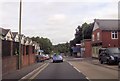
Shopping on Bournemouth Road
Close to Chandlers Ford Station
Image: © John Firth
Taken: 19 Sep 2013
0.05 miles