IMAGES TAKEN NEAR TO
Guildford Drive, EASTLEIGH, SO53 3PS
Introduction
This page details the photographs taken nearby to Guildford Drive, SO53 3PS by members of the Geograph project.
The Geograph project started in 2005 with the aim of publishing, organising and preserving representative images for every square kilometre of Great Britain, Ireland and the Isle of Man.

There are currently over 7.5m images from over14,400 individuals and you can help contribute to the project by visiting https://www.geograph.org.uk
Image Map
Images are licensed for reuse under creativecommons.org/licenses/by-sa/2.0
Notes
- Clicking on the map will re-center to the selected point.
- The higher the marker number, the further away the image location is from the centre of the postcode.
Image Listing (18 Images Found)
Images are licensed for reuse under creativecommons.org/licenses/by-sa/2.0
Image
Details
Distance
1

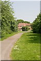
Path crossing Montgomery Way, Chandlers Ford
This residential area is well served by paths and cycleways separated from the roads.
Image: © Peter Facey
Taken: 14 May 2008
0.06 miles

3
Path east of Conway Close, Chandler's Ford
This residential area is well served by paths and cycleways away from roads.
Image: © Peter Facey
Taken: 14 May 2008
0.13 miles
6
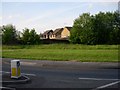
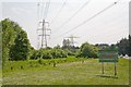
New Housing
A relatively new housing estate and some of the open space left under some power lines.
Image: © Hugh Venables
Taken: 31 May 2006
0.16 miles
7
The end of the line at Velmore electricity substation, Chandlers Ford
The righthand line carries power at 132 KV from Nursling substation to Velmore substation which supplies Chandlers Ford. Here it goes underground for the last 200m to the substation. This enables it to cross under the lefthand line which is part of the supergrid carrying power at 400 KV between Nursling and Lovedean substations. It is merely passing overhead.
Image: © Peter Facey
Taken: 14 May 2008
0.17 miles
8
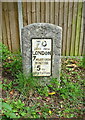
Milestone beside Bournemouth Road (B3043)
Inscription reads:-
70
Miles From
LONDON
7 Miles From
WINTON
5 To
SOUTHTON
IRS Ltd Norfolk.
Milestone Society National ID: HA_WISO07.
Image: © JThomas
Taken: 25 Apr 2022
0.20 miles
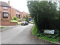
9

Secure House, Chandler's Ford
The nameplate is on Templars Way, but the office building it refers to is behind the trees, in Lulworth Close. See Image
Image: © Christine Johnstone
Taken: 8 Nov 2021
0.21 miles
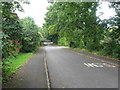
10
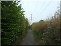
Urban path under the power lines
Heading west from Bournemouth Road, Chandler's Ford.
Image: © Christine Johnstone
Taken: 8 Nov 2021
0.21 miles