IMAGES TAKEN NEAR TO
Hardwick Road, EASTLEIGH, SO53 2GZ
Introduction
This page details the photographs taken nearby to Hardwick Road, SO53 2GZ by members of the Geograph project.
The Geograph project started in 2005 with the aim of publishing, organising and preserving representative images for every square kilometre of Great Britain, Ireland and the Isle of Man.

There are currently over 7.5m images from over14,400 individuals and you can help contribute to the project by visiting https://www.geograph.org.uk
Image Map
Images are licensed for reuse under creativecommons.org/licenses/by-sa/2.0
Notes
- Clicking on the map will re-center to the selected point.
- The higher the marker number, the further away the image location is from the centre of the postcode.
Image Listing (88 Images Found)
Images are licensed for reuse under creativecommons.org/licenses/by-sa/2.0
Image
Details
Distance
2
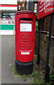
Elizabeth II postbox on Hursley Road, Chandler's Ford
Outside the Post Office.
Postbox No. SO53 355.
See Image] for context.
Image: © JThomas
Taken: 25 Apr 2022
0.10 miles
3
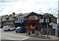
Businesses on Bournemouth Road, Chandler's Ford
Showing position of Postbox No. SO53 417.
See Image] for postbox.
Image: © JThomas
Taken: 25 Apr 2022
0.10 miles
4
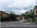
Roundabout in Chandler's Ford
Classic 'cobblestone' type roundabout. The B3043 passes over the Romsey to Eastleigh railway line just beyond the roundabout.
Image: © peter clayton
Taken: 4 Jan 2009
0.13 miles
5
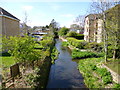
Chandler's Ford, Monks Brook
Looking upstream at a brook that rises in North Baddesley and flows into River Itchen at Swaythling.
Image: © Mike Faherty
Taken: 21 Apr 2012
0.13 miles
6
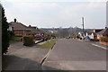
Craven Road, Chandler's Ford
Running downhill from Fryern Hill.
Image: © Peter Facey
Taken: 28 Mar 2013
0.13 miles
7
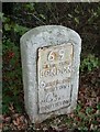
Old Milestone by Winchester Road, Fryern Hill
Metal plate attached to stone post by the UC road, in parish of NORTH BADDESLEY (TEST VALLEY District), Fryern Hill, junction of Bodycoats Road and Winchester Road, opposite 47 Winchester Road, by the road, on Southeast side of road. Winton plate, erected by the Southampton, North District turnpike trust in the 19th century.
Inscription reads:-
69
Miles From
LONDON
6 Miles From
WINTON
6 To
SOUTHTON
Milestone Society National ID: HA_WISO06.
Image: © K Lawrence
Taken: 23 May 2003
0.15 miles
8
Chandler's Ford, Central Precinct
On Winchester Road; premises on the main road include bank, estate agents, coffee bar, insurance agent, IT services, fish and chips and vacant; there are more out of sight.
Image: © Mike Faherty
Taken: 21 Apr 2012
0.15 miles
9

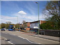
Railway towards Eastleigh
From the bridge on the B3043.
Image: © JThomas
Taken: 25 Apr 2022
0.16 miles
10
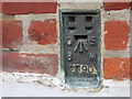
Ordnance Survey Flush Bracket 2790
This can be found on the wall of a house -private flats - in Winchester Road, Chandlers Ford.
For more detail see : http://www.bench-marks.org.uk/bm10491
Image: © Peter Wood
Taken: 26 Feb 2017
0.16 miles