IMAGES TAKEN NEAR TO
Avonborne Way, EASTLEIGH, SO53 1TF
Introduction
This page details the photographs taken nearby to Avonborne Way, SO53 1TF by members of the Geograph project.
The Geograph project started in 2005 with the aim of publishing, organising and preserving representative images for every square kilometre of Great Britain, Ireland and the Isle of Man.

There are currently over 7.5m images from over14,400 individuals and you can help contribute to the project by visiting https://www.geograph.org.uk
Image Map
Images are licensed for reuse under creativecommons.org/licenses/by-sa/2.0
Notes
- Clicking on the map will re-center to the selected point.
- The higher the marker number, the further away the image location is from the centre of the postcode.
Image Listing (13 Images Found)
Images are licensed for reuse under creativecommons.org/licenses/by-sa/2.0
Image
Details
Distance

3
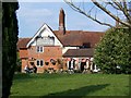
Farmhouse pub
Hiltonbury Farm house (not Hiltingbury)
Image: © Robin Baker
Taken: 8 Apr 2007
0.15 miles
4
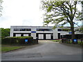
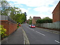
Draper Tools Head Office, Chandler's Ford
On Hursley Road.
Image: © JThomas
Taken: 25 Apr 2022
0.17 miles
7

Ramalley Cemetery
A municipal cemetery operated by Eastleigh Borough Council.
Image: © Graham Horn
Taken: 19 Mar 2011
0.19 miles
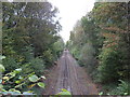
8
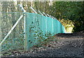
Fence by the railway
To the left is a bridge over the Romsey to Eastleigh railway line. It is well protected from trespassers by this fence.
Image: © Graham Horn
Taken: 19 Mar 2011
0.20 miles