IMAGES TAKEN NEAR TO
Park Road, EASTLEIGH, SO53 1HS
Introduction
This page details the photographs taken nearby to Park Road, SO53 1HS by members of the Geograph project.
The Geograph project started in 2005 with the aim of publishing, organising and preserving representative images for every square kilometre of Great Britain, Ireland and the Isle of Man.

There are currently over 7.5m images from over14,400 individuals and you can help contribute to the project by visiting https://www.geograph.org.uk
Image Map
Images are licensed for reuse under creativecommons.org/licenses/by-sa/2.0
Notes
- Clicking on the map will re-center to the selected point.
- The higher the marker number, the further away the image location is from the centre of the postcode.
Image Listing (6 Images Found)
Images are licensed for reuse under creativecommons.org/licenses/by-sa/2.0
Image
Details
Distance
2
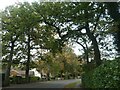
Hiltingbury Park
Hiltingbury pavilion on right hand side of photo.
Image: © Robin Baker
Taken: 9 Apr 2007
0.21 miles
4
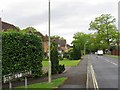
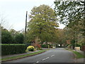
Trees along Oakwood Road, Chandler's Ford
Before the'march of bricks and mortar' this was part of the heavily wooded Hiltingbury Common.
Image: © Christine Johnstone
Taken: 8 Nov 2021
0.22 miles
5
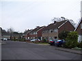
Oakwood Road, Chandler's Ford
This road was laid out between 1895 and 1908, but there were very few houses on it until after 1945.
Image: © Christine Johnstone
Taken: 8 Nov 2021
0.23 miles
6
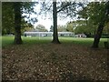
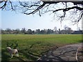
Sports field, Sherborne House School
A fee-paying school for children aged 3 - 11, in Chandler's Ford.
Image: © Christine Johnstone
Taken: 8 Nov 2021
0.25 miles