IMAGES TAKEN NEAR TO
Dove Dale, EASTLEIGH, SO50 9LE
Introduction
This page details the photographs taken nearby to Dove Dale, SO50 9LE by members of the Geograph project.
The Geograph project started in 2005 with the aim of publishing, organising and preserving representative images for every square kilometre of Great Britain, Ireland and the Isle of Man.

There are currently over 7.5m images from over14,400 individuals and you can help contribute to the project by visiting https://www.geograph.org.uk
Image Map
Images are licensed for reuse under creativecommons.org/licenses/by-sa/2.0
Notes
- Clicking on the map will re-center to the selected point.
- The higher the marker number, the further away the image location is from the centre of the postcode.
Image Listing (70 Images Found)
Images are licensed for reuse under creativecommons.org/licenses/by-sa/2.0
Image
Details
Distance
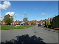
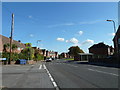
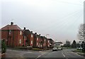
4
Looking from Nightingale Avenue into Woodpecker Way (western end)
Image: © Basher Eyre
Taken: 1 Jul 2011
0.09 miles
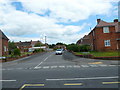
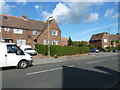
6
Junction of Sparrow Square and Nightingale Avenue
Image: © Basher Eyre
Taken: 20 Oct 2011
0.10 miles
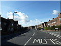
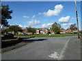
10
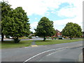
Green between Blackbird Road and Nightingale Avenue
Image: © Basher Eyre
Taken: 1 Jul 2011
0.11 miles