IMAGES TAKEN NEAR TO
Archers Road, EASTLEIGH, SO50 9BG
Introduction
This page details the photographs taken nearby to Archers Road, SO50 9BG by members of the Geograph project.
The Geograph project started in 2005 with the aim of publishing, organising and preserving representative images for every square kilometre of Great Britain, Ireland and the Isle of Man.

There are currently over 7.5m images from over14,400 individuals and you can help contribute to the project by visiting https://www.geograph.org.uk
Image Map
Images are licensed for reuse under creativecommons.org/licenses/by-sa/2.0
Notes
- Clicking on the map will re-center to the selected point.
- The higher the marker number, the further away the image location is from the centre of the postcode.
Image Listing (91 Images Found)
Images are licensed for reuse under creativecommons.org/licenses/by-sa/2.0
Image
Details
Distance
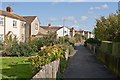
1
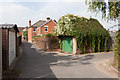
Garage of number 104 Archers Road
Looking along an alley running parallel to The Crescent. The brick house on the right of the alley is number 104 on Archers Road (which is left to right ahead). Its garage is well covered with creeper.
Image: © Peter Facey
Taken: 25 Sep 2013
0.01 miles
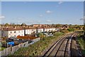
2
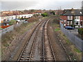
Railway heading east as seen from the Archers Road footbridge
Image: © Basher Eyre
Taken: 12 Dec 2009
0.02 miles
3
Closed end of Archers Road
Seen from atop the railway footbridge.
Image: © Peter Facey
Taken: 25 Sep 2013
0.02 miles
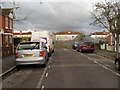
5
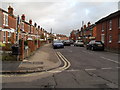
Looking from Archers Road into The Crescent
Image: © Basher Eyre
Taken: 12 Dec 2009
0.03 miles
6
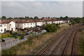
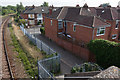
Houses in The Quadrangle
Backing onto the railway line. Seen from atop the railway footbridge.
Image: © Peter Facey
Taken: 25 Sep 2013
0.03 miles
7
Railway heading west as seen from the Archers Road footbridge
Image: © Basher Eyre
Taken: 12 Dec 2009
0.03 miles
8
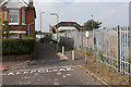
Railway footbridge at end of Archers Road
Archers Road is a cul de sac running from The Crescent to the railway line.
Image: © Peter Facey
Taken: 25 Sep 2013
0.04 miles
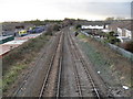
9
Railway lines approaching Eastleigh Station
On the left are the backs of houses in The Quadrangle. Seen from footbridge over the railway.
Image: © Peter Facey
Taken: 28 Oct 2008
0.04 miles
10
Footpath to The Quadrangle
These houses are around the outer edge of The Quadrangle. Behind camera is a footpath that goes over the railway line.
Image: © Peter Facey
Taken: 28 Oct 2008
0.05 miles