IMAGES TAKEN NEAR TO
Hensting Lane, EASTLEIGH, SO50 7HH
Introduction
This page details the photographs taken nearby to Hensting Lane, SO50 7HH by members of the Geograph project.
The Geograph project started in 2005 with the aim of publishing, organising and preserving representative images for every square kilometre of Great Britain, Ireland and the Isle of Man.

There are currently over 7.5m images from over14,400 individuals and you can help contribute to the project by visiting https://www.geograph.org.uk
Image Map
Images are licensed for reuse under creativecommons.org/licenses/by-sa/2.0
Notes
- Clicking on the map will re-center to the selected point.
- The higher the marker number, the further away the image location is from the centre of the postcode.
Image Listing (19 Images Found)
Images are licensed for reuse under creativecommons.org/licenses/by-sa/2.0
Image
Details
Distance
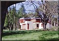
1
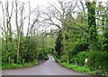
View from Castle Lane towards Swifts Farm
Castle Lane is a footpath that is extremely wet. Swifts Farm is mainly business units.
Image: © Peter Facey
Taken: 3 Dec 2006
0.04 miles
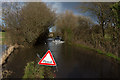
2
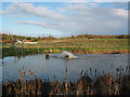
Fish farm in Hensting Lane
One of the smaller pools of the fish farm, the biggest one being Fishers Pond. The machine churning up the water is an oxygenator. Hensting Lane runs along the left of the picture, and the building in the distance is the Hampshire Riding Therapy Centre.
Image: © Peter Facey
Taken: 3 Dec 2006
0.12 miles
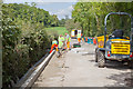
3

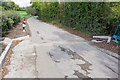
Sweeping up after road planing in Hensting Lane
A smaller road planer has been used here on the most damaged section of the lane to take a deeper cut. The planed down part of the road on the left will then be filled with a base course to bring it up to the level seen on the right. The whole will then have a 45 mm surface course applied.
Image: © Peter Facey
Taken: 10 Oct 2011
0.13 miles
4
Drainage works in Hensting Lane
O'Rourke Southern Ltd, subcontractors to Amey, carry out drainage works. Part of Hampshire County Council's Operation Resilience (http://www3.hants.gov.uk/roads/operation-resilience.htm ) designed to deal with the fundamental causes of road surface deterioration, these works will get rid of the running and standing water normally present on this lane which has caused the extensive pot holing. The ditch on the left used to get filled in by passing traffic, and by roots from the hedge, causing water to run across the road surface and accumulate on the righthand side. The ditch is being put in a pipe, a passing place is being made, and the final road camber will make the water flow leftwards into the ditch.
Later http://www.geograph.org.uk/photo/2636299
Image: © Peter Facey
Taken: 16 Sep 2011
0.13 miles
5
New drains in Hensting Lane
The road here is to have 45 mm of tarmac laid on top of the old surface, and the camber is to be changed so that it drains mainly to the left (rather than, as before, mainly to the right). Here can be seen two new drains, one on each side of the road. Earlier http://www.geograph.org.uk/photo/2604834
Image: © Peter Facey
Taken: 7 Oct 2011
0.14 miles
7
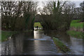
River flowing down Hensting Lane
In normal times the water is confined to the stream seen on the right of the grass strip.
Image: © Peter Facey
Taken: 9 Feb 2014
0.14 miles
8
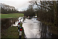
River flowing down Hensting Lane
Flowing towards the camera. The pond to the left of the fence is normally a grass field. The stream to the right of the fence and the left of the bollards is always there. It passes through a culvert to the right hand side of the Lane here.
Image: © Peter Facey
Taken: 9 Feb 2014
0.14 miles
9
River flowing down Hensting Lane
Flowing towards the camera. The water is normally confined to the stream at left.
Image: © Peter Facey
Taken: 9 Feb 2014
0.15 miles