IMAGES TAKEN NEAR TO
Brambridge, EASTLEIGH, SO50 6HZ
Introduction
This page details the photographs taken nearby to SO50 6HZ by members of the Geograph project.
The Geograph project started in 2005 with the aim of publishing, organising and preserving representative images for every square kilometre of Great Britain, Ireland and the Isle of Man.

There are currently over 7.5m images from over14,400 individuals and you can help contribute to the project by visiting https://www.geograph.org.uk
Image Map
Images are licensed for reuse under creativecommons.org/licenses/by-sa/2.0
Notes
- Clicking on the map will re-center to the selected point.
- The higher the marker number, the further away the image location is from the centre of the postcode.
Image Listing (37 Images Found)
Images are licensed for reuse under creativecommons.org/licenses/by-sa/2.0
Image
Details
Distance
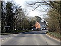
1
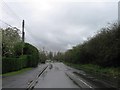
Western end of Church Lane, Brambridge
Looking towards its T junction with Highbridge Road. A view familiar to motorists as there is usually a queue here in the morning rush hour, as people try to get to Eastleigh or onto the M3 at junction 12.
Image: © Peter Facey
Taken: 11 Jun 2006
0.03 miles
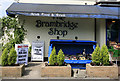
3
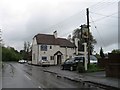
Brambridge and Church Lane
Brambridge Shop (the blue tarpaulin) and beyond the Dog & Crook pub. On right, Church Lane which meets Highbridge Road in a T junction in distance. Road at left is a little loop forming The Crescent.
Image: © Peter Facey
Taken: 11 Jun 2006
0.04 miles
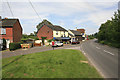
4
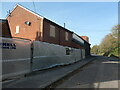
Building works, Church Lane, Brambridge
Where an older bend in the lane has been by-passed by a straighter length of road.
Image: © Christine Johnstone
Taken: 7 Nov 2021
0.04 miles
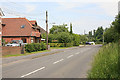
5
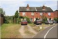
The Crescent, Brambridge
These houses form The Crescent as noted on the black plaque. Off picture right is Brambridge Shop and Church Lane.
Image: © Peter Facey
Taken: 11 Jun 2006
0.05 miles
8
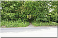
Footpath to Upper Moors Road from Brambridge
The footpath crosses Church Lane, Brambridge here. If you didn't know this path was there you probably wouldn't notice it.
Image: © Peter Facey
Taken: 11 Jun 2006
0.05 miles
9
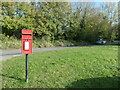
Post box, Church Lane, Brambridge
On a crescent of grass created when a sharp bend in the lane was straightened.
Image: © Christine Johnstone
Taken: 7 Nov 2021
0.06 miles