IMAGES TAKEN NEAR TO
Desborough Road, EASTLEIGH, SO50 5NH
Introduction
This page details the photographs taken nearby to Desborough Road, SO50 5NH by members of the Geograph project.
The Geograph project started in 2005 with the aim of publishing, organising and preserving representative images for every square kilometre of Great Britain, Ireland and the Isle of Man.

There are currently over 7.5m images from over14,400 individuals and you can help contribute to the project by visiting https://www.geograph.org.uk
Image Map
Images are licensed for reuse under creativecommons.org/licenses/by-sa/2.0
Notes
- Clicking on the map will re-center to the selected point.
- The higher the marker number, the further away the image location is from the centre of the postcode.
Image Listing (167 Images Found)
Images are licensed for reuse under creativecommons.org/licenses/by-sa/2.0
Image
Details
Distance
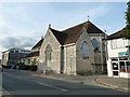
2

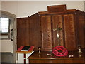
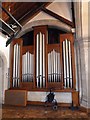
All Saints' Church, Eastleigh- October 2011 (4)
Image: © Basher Eyre
Taken: 20 Oct 2011
0.04 miles
3
All Saints' Church, Eastleigh- October 2011 (1)
Image: © Basher Eyre
Taken: 20 Oct 2011
0.04 miles
4
All Saints' Church, Eastleigh- October 2011 (2)
Image: © Basher Eyre
Taken: 20 Oct 2011
0.04 miles
5

All Saints' Church, Eastleigh- October 2011 (3)
Image: © Basher Eyre
Taken: 20 Oct 2011
0.04 miles

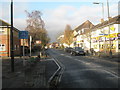
7
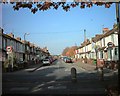
Junction of Derby Road and Chamberlayne Road
The houses were built in the first 10 years of the twentieth century
Image: © Steve Rigg
Taken: 10 Nov 2003
0.04 miles
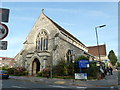
8
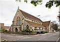
All Saints' Church, Eastleigh
On the corner of Derby Road and Desborough Road. http://www.allsaintseastleigh.co.uk/
Image: © Peter Facey
Taken: 26 Jun 2007
0.05 miles