IMAGES TAKEN NEAR TO
High Street, EASTLEIGH, SO50 5LW
Introduction
This page details the photographs taken nearby to High Street, SO50 5LW by members of the Geograph project.
The Geograph project started in 2005 with the aim of publishing, organising and preserving representative images for every square kilometre of Great Britain, Ireland and the Isle of Man.

There are currently over 7.5m images from over14,400 individuals and you can help contribute to the project by visiting https://www.geograph.org.uk
Image Map
Images are licensed for reuse under creativecommons.org/licenses/by-sa/2.0
Notes
- Clicking on the map will re-center to the selected point.
- The higher the marker number, the further away the image location is from the centre of the postcode.
Image Listing (214 Images Found)
Images are licensed for reuse under creativecommons.org/licenses/by-sa/2.0
Image
Details
Distance
2
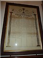
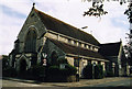
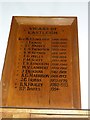
All Saints' Church, Eastleigh- Roll of Honour
Image: © Basher Eyre
Taken: 26 Nov 2011
0.03 miles
3
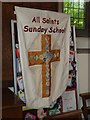
All Saints, Eastleigh- Sunday School banner
Image: © Basher Eyre
Taken: 26 Nov 2011
0.03 miles
9
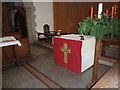
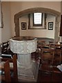
All Saints' Church, Eastleigh- The Lord's Table
Image: © Basher Eyre
Taken: 26 Nov 2011
0.04 miles
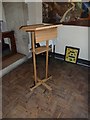
10
All Saints' Church, Eastleigh- incumbency board
Image: © Basher Eyre
Taken: 26 Nov 2011
0.04 miles