IMAGES TAKEN NEAR TO
Tennyson Road, EASTLEIGH, SO50 5EB
Introduction
This page details the photographs taken nearby to Tennyson Road, SO50 5EB by members of the Geograph project.
The Geograph project started in 2005 with the aim of publishing, organising and preserving representative images for every square kilometre of Great Britain, Ireland and the Isle of Man.

There are currently over 7.5m images from over14,400 individuals and you can help contribute to the project by visiting https://www.geograph.org.uk
Image Map
Images are licensed for reuse under creativecommons.org/licenses/by-sa/2.0
Notes
- Clicking on the map will re-center to the selected point.
- The higher the marker number, the further away the image location is from the centre of the postcode.
Image Listing (74 Images Found)
Images are licensed for reuse under creativecommons.org/licenses/by-sa/2.0
Image
Details
Distance
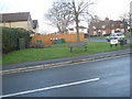
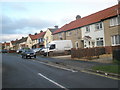
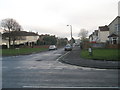
2
Looking from Locksley Road into Tennyson Road
Image: © Basher Eyre
Taken: 12 Dec 2009
0.02 miles
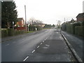
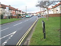
3
Staggered crossroads in Tennyson Road
Cherbourg Road to the left; Locksley Road to the right
Image: © Basher Eyre
Taken: 12 Dec 2009
0.03 miles
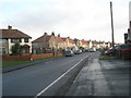
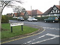
8
Looking from Derby Road into Tennyson Road
Image: © Basher Eyre
Taken: 12 Dec 2009
0.06 miles
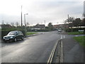
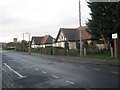
9
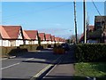
Cherbourg Road, Eastleigh
Along the western end of Cherbourg Road lie these bungalows - sheltered accommodation.
Image: © Steve Rigg
Taken: 21 Jan 2006
0.07 miles