IMAGES TAKEN NEAR TO
Chestnut Avenue, EASTLEIGH, SO50 5BU
Introduction
This page details the photographs taken nearby to Chestnut Avenue, SO50 5BU by members of the Geograph project.
The Geograph project started in 2005 with the aim of publishing, organising and preserving representative images for every square kilometre of Great Britain, Ireland and the Isle of Man.

There are currently over 7.5m images from over14,400 individuals and you can help contribute to the project by visiting https://www.geograph.org.uk
Image Map
Images are licensed for reuse under creativecommons.org/licenses/by-sa/2.0
Notes
- Clicking on the map will re-center to the selected point.
- The higher the marker number, the further away the image location is from the centre of the postcode.
Image Listing (30 Images Found)
Images are licensed for reuse under creativecommons.org/licenses/by-sa/2.0
Image
Details
Distance
1
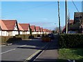
Cherbourg Road, Eastleigh
Along the western end of Cherbourg Road lie these bungalows - sheltered accommodation.
Image: © Steve Rigg
Taken: 21 Jan 2006
0.11 miles
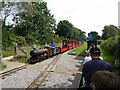
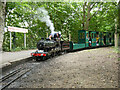
5
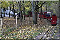
Train leaving Monks Brook Halt, Eastleigh Lakeside Railway
Image: © David Martin
Taken: 3 Dec 2022
0.17 miles
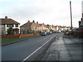
6
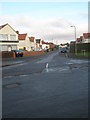
Looking from Locksley Road into Burns Road
Image: © Basher Eyre
Taken: 12 Dec 2009
0.17 miles
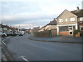
7
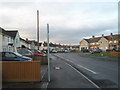
Approaching the crossroads of Burns Road and Locksley Road
Image: © Basher Eyre
Taken: 12 Dec 2009
0.17 miles
8
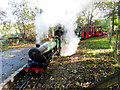
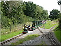
Eastleigh Lakeside Railway
Locomotive No. 2005 Silver Jubilee, a 4-6-2 built by HCS Bullock in 1935 is seen on arrival at Monk's Brook station.
Image: © Gareth James
Taken: 27 Oct 2019
0.18 miles
9
Monks Brook Halt on the Eastleigh Lakeside Railway
Image: © Gareth James
Taken: 11 Aug 2023
0.18 miles