IMAGES TAKEN NEAR TO
Arrow Close, EASTLEIGH, SO50 4SU
Introduction
This page details the photographs taken nearby to Arrow Close, SO50 4SU by members of the Geograph project.
The Geograph project started in 2005 with the aim of publishing, organising and preserving representative images for every square kilometre of Great Britain, Ireland and the Isle of Man.

There are currently over 7.5m images from over14,400 individuals and you can help contribute to the project by visiting https://www.geograph.org.uk
Image Map
Images are licensed for reuse under creativecommons.org/licenses/by-sa/2.0
Notes
- Clicking on the map will re-center to the selected point.
- The higher the marker number, the further away the image location is from the centre of the postcode.
Image Listing (106 Images Found)
Images are licensed for reuse under creativecommons.org/licenses/by-sa/2.0
Image
Details
Distance
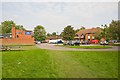
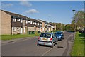
1
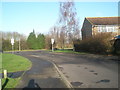
Looking up Selborne Drive towards Shakespeare Road
Image: © Basher Eyre
Taken: 12 Dec 2009
0.03 miles
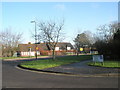
2
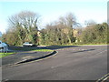
Junction of Shakespeare Road and Selborne Close
Image: © Basher Eyre
Taken: 12 Dec 2009
0.03 miles
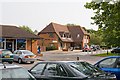
5
The Arrow pub and shops, Shakespeare Road
The pub at left; shops and a veterinary surgery in Chesil House at right.
Image: © Peter Facey
Taken: 15 Sep 2008
0.05 miles
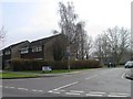
6
Looking from Selborne Drive over to Shakespeare Infant School
Image: © Basher Eyre
Taken: 12 Dec 2009
0.05 miles
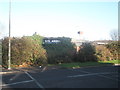
7
Boyatt Wood shopping centre, Shakespeare Road
With Chesil House centre right.
Image: © Peter Facey
Taken: 15 Sep 2008
0.05 miles
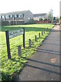
9
Housing in Selbourne Drive
At its northern end as it approaches Shakespeare Road.
Image: © Peter Facey
Taken: 28 Oct 2008
0.06 miles
10
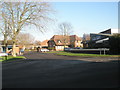
Looking from Shakespeare Road into Arrow Close
Image: © Basher Eyre
Taken: 12 Dec 2009
0.06 miles