IMAGES TAKEN NEAR TO
Shakespeare Road, EASTLEIGH, SO50 4SF
Introduction
This page details the photographs taken nearby to Shakespeare Road, SO50 4SF by members of the Geograph project.
The Geograph project started in 2005 with the aim of publishing, organising and preserving representative images for every square kilometre of Great Britain, Ireland and the Isle of Man.

There are currently over 7.5m images from over14,400 individuals and you can help contribute to the project by visiting https://www.geograph.org.uk
Image Map
Images are licensed for reuse under creativecommons.org/licenses/by-sa/2.0
Notes
- Clicking on the map will re-center to the selected point.
- The higher the marker number, the further away the image location is from the centre of the postcode.
Image Listing (64 Images Found)
Images are licensed for reuse under creativecommons.org/licenses/by-sa/2.0
Image
Details
Distance
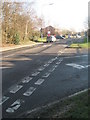
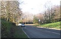
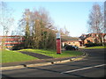
2
Approaching the junction of Woodside Avenue and Shakespeare Road
Image: © Basher Eyre
Taken: 12 Dec 2009
0.04 miles
3
Looking from the B & Q access road along Shakespeare Road
Image: © Basher Eyre
Taken: 12 Dec 2009
0.05 miles
4
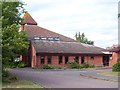
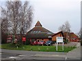
Boyatt Wood Church
The Church of St Peter, Boyatt Wood
Image: © Steve Rigg
Taken: 19 Jul 2005
0.05 miles
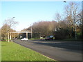
5
Looking from Goodwood Road across Woodside Avenue towards B & Q
Image: © Basher Eyre
Taken: 12 Dec 2009
0.05 miles
6
Looking along Shakespeare Road towards Woodside Avenue
Image: © Basher Eyre
Taken: 12 Dec 2009
0.05 miles
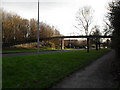
7

Junction of Woodside Avenue and Shakespeare Road
Image: © Basher Eyre
Taken: 12 Dec 2009
0.07 miles
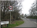
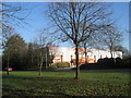
9
Approaching Crestwood College from Shakespeare Road
Image: © Basher Eyre
Taken: 12 Dec 2009
0.07 miles