IMAGES TAKEN NEAR TO
Allbrook Knoll, EASTLEIGH, SO50 4RY
Introduction
This page details the photographs taken nearby to Allbrook Knoll, SO50 4RY by members of the Geograph project.
The Geograph project started in 2005 with the aim of publishing, organising and preserving representative images for every square kilometre of Great Britain, Ireland and the Isle of Man.

There are currently over 7.5m images from over14,400 individuals and you can help contribute to the project by visiting https://www.geograph.org.uk
Image Map
Images are licensed for reuse under creativecommons.org/licenses/by-sa/2.0
Notes
- Clicking on the map will re-center to the selected point.
- The higher the marker number, the further away the image location is from the centre of the postcode.
Image Listing (46 Images Found)
Images are licensed for reuse under creativecommons.org/licenses/by-sa/2.0
Image
Details
Distance
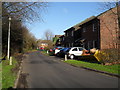
4
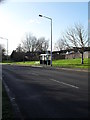
Approaching the junction of Bosville and Woodside Avenue
Image: © Basher Eyre
Taken: 12 Dec 2009
0.11 miles
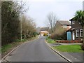
5
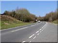
Looking from Allbrook Knoll into Woodside Avenue
Image: © Basher Eyre
Taken: 12 Dec 2009
0.13 miles
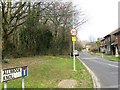
9
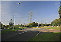
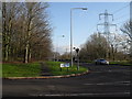
Roundabout at Allbrook, nr Eastleigh
Looking up Allbrook Hill. 3rd exit takes you to M3 Jn 12 via Allbrook Way. Pylon in background is part of 400 KV supergrid running from Nursling to Lovedean substations.
Image: © Peter Facey
Taken: 17 Sep 2006
0.16 miles
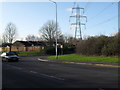
10
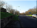
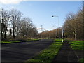
Looking westwards along Woodside Avenue
Image: © Basher Eyre
Taken: 12 Dec 2009
0.16 miles