IMAGES TAKEN NEAR TO
Woburn Close, EASTLEIGH, SO50 4RG
Introduction
This page details the photographs taken nearby to Woburn Close, SO50 4RG by members of the Geograph project.
The Geograph project started in 2005 with the aim of publishing, organising and preserving representative images for every square kilometre of Great Britain, Ireland and the Isle of Man.

There are currently over 7.5m images from over14,400 individuals and you can help contribute to the project by visiting https://www.geograph.org.uk
Image Map
Images are licensed for reuse under creativecommons.org/licenses/by-sa/2.0
Notes
- Clicking on the map will re-center to the selected point.
- The higher the marker number, the further away the image location is from the centre of the postcode.
Image Listing (99 Images Found)
Images are licensed for reuse under creativecommons.org/licenses/by-sa/2.0
Image
Details
Distance
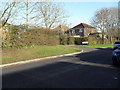
2
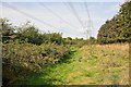
Rough land beside Woodside Avenue
Had it not been for these 400 KV electricity lines, this land would almost certainly have been built on by now.
Image: © Peter Facey
Taken: 13 Sep 2008
0.04 miles
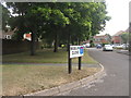
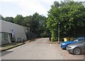
3
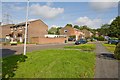
Penshurst Way, Boyatt Wood
Penshurst Way (looking south), Boyatt Wood is a small estate just to the north of Eastleigh in the county of Hampshire
Image: © Paul Smith
Taken: 1 Jun 2005
0.04 miles
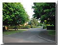
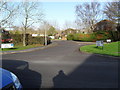
4
Approaching the junction of Broadlands Avenue and Penshurst Way
Image: © Basher Eyre
Taken: 12 Dec 2009
0.04 miles
5
Approaching a spur in Broadlands Avenue
Image: © Basher Eyre
Taken: 12 Dec 2009
0.04 miles
6
Looking from Broadlands Avenue into Penshurst Way
Image: © Basher Eyre
Taken: 12 Dec 2009
0.04 miles

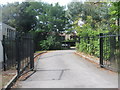
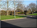
10
Penshurst Way
With Claremont Close on the left.
Image: © Peter Facey
Taken: 13 Sep 2008
0.06 miles