IMAGES TAKEN NEAR TO
Pitmore Road, EASTLEIGH, SO50 4LX
Introduction
This page details the photographs taken nearby to Pitmore Road, SO50 4LX by members of the Geograph project.
The Geograph project started in 2005 with the aim of publishing, organising and preserving representative images for every square kilometre of Great Britain, Ireland and the Isle of Man.

There are currently over 7.5m images from over14,400 individuals and you can help contribute to the project by visiting https://www.geograph.org.uk
Image Map
Images are licensed for reuse under creativecommons.org/licenses/by-sa/2.0
Notes
- Clicking on the map will re-center to the selected point.
- The higher the marker number, the further away the image location is from the centre of the postcode.
Image Listing (8 Images Found)
Images are licensed for reuse under creativecommons.org/licenses/by-sa/2.0
Image
Details
Distance
2
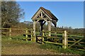
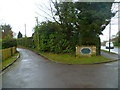
Entrance to Allbrook Meadow
The lychgate-style entrance is dated 2015.
Image: © David Martin
Taken: 3 Jan 2025
0.11 miles
5
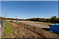
Development at Allbrook Farm
This is the field behind Image Pitmore Road is on the left, and the new access road to development curves towards the blue shed.
Image: © Peter Facey
Taken: 14 Oct 2012
0.22 miles
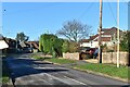
8
Junction of Park Lane and Pitmore Road
Park Lane, to the left, is also a footpath for a short distance.
Image: © Shazz
Taken: 18 Mar 2013
0.24 miles