IMAGES TAKEN NEAR TO
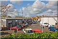
Twyford Road, EASTLEIGH, SO50 4HD
Introduction
This page details the photographs taken nearby to Twyford Road, SO50 4HD by members of the Geograph project.
The Geograph project started in 2005 with the aim of publishing, organising and preserving representative images for every square kilometre of Great Britain, Ireland and the Isle of Man.

There are currently over 7.5m images from over14,400 individuals and you can help contribute to the project by visiting https://www.geograph.org.uk
Image Map
Images are licensed for reuse under creativecommons.org/licenses/by-sa/2.0
Notes
- Clicking on the map will re-center to the selected point.
- The higher the marker number, the further away the image location is from the centre of the postcode.
Image Listing (113 Images Found)
Images are licensed for reuse under creativecommons.org/licenses/by-sa/2.0
Image
Details
Distance
1
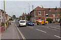
Mill Street joins Twyford Road
The dumper truck is coming out of Mill Street, wherein lies a Travis Perkins depot.
Image: © Peter Facey
Taken: 25 Sep 2013
0.01 miles
2
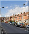
Mill Street
A residential cul de sac which also provides access to Image Looking towards its junction with Twyford Road.
Image: © Peter Facey
Taken: 28 Oct 2008
0.02 miles
3
Twyford Road passes over the railway lines
Image: © Peter Facey
Taken: 28 Oct 2008
0.04 miles
4
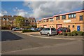
Shakespeare Business Centre, Hathaway Close
Housing in left distance is in Stratford Place.
Image: © Peter Facey
Taken: 28 Oct 2008
0.04 miles
5
Shakespeare Business Centre, Hathaway Close
Looking down on it from Twyford Road which is raised here to go over the railway line.
Image: © Peter Facey
Taken: 28 Oct 2008
0.05 miles
6
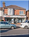
Eastleigh Services shop in Twyford Road
Image: © Peter Facey
Taken: 28 Oct 2008
0.05 miles
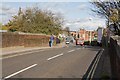
7
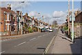
Twyford Road
Looking north from its junction with Shakespeare Road.
Image: © Peter Facey
Taken: 28 Oct 2008
0.06 miles
8
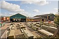
Timber yard of Travis Perkins builders merchants
Seen from Twyford Road which is here raised to go over the railway line.
Image: © Peter Facey
Taken: 28 Oct 2008
0.07 miles
9
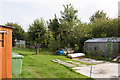
Garden between railway line and The Crescent
Houses on the north eastern side of The Crescent have back gardens which abut onto an alley in which the photographer is standing. These gardens lie between that alley and the railway line. It is not clear if the gardens are associated with the houses or if they are independently owned.
Image: © Peter Facey
Taken: 25 Sep 2013
0.07 miles
10
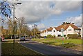
Shakespeare Road
Opposite Stratford Place.
Image: © Peter Facey
Taken: 28 Oct 2008
0.08 miles