IMAGES TAKEN NEAR TO
St. Catherines Road, EASTLEIGH, SO50 4GP
Introduction
This page details the photographs taken nearby to St. Catherines Road, SO50 4GP by members of the Geograph project.
The Geograph project started in 2005 with the aim of publishing, organising and preserving representative images for every square kilometre of Great Britain, Ireland and the Isle of Man.

There are currently over 7.5m images from over14,400 individuals and you can help contribute to the project by visiting https://www.geograph.org.uk
Image Map
Images are licensed for reuse under creativecommons.org/licenses/by-sa/2.0
Notes
- Clicking on the map will re-center to the selected point.
- The higher the marker number, the further away the image location is from the centre of the postcode.
Image Listing (64 Images Found)
Images are licensed for reuse under creativecommons.org/licenses/by-sa/2.0
Image
Details
Distance
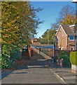
1
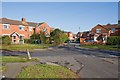
The Nook, St Catherine's Road
Looking across St Catherine's Road from Darwin Road, The Nook is the cul de sac opposite.
Image: © Peter Facey
Taken: 28 Oct 2008
0.02 miles
2
The Recess, St Catherine's Road
Looking across St Catherine's Road at this residential cul de sac.
Image: © Peter Facey
Taken: 28 Oct 2008
0.02 miles
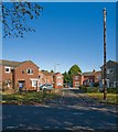
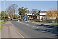
3
Junction of St Catherine's Road and Twyford Road
Looking across Twyford Road into St Catherine's Road. The seat is on a small triangular island.
Image: © Peter Facey
Taken: 28 Oct 2008
0.02 miles
4
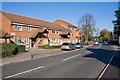
Drummond Court, Twyford Road
I believe this is a housing association property. It is on the corner of Twyford Road and St Catherine's Road.
Image: © Peter Facey
Taken: 28 Oct 2008
0.05 miles
5
Steps from Consort Road to Twyford Road
The southern end of Consort Road turns ninety degrees to the west, and that is the bit we are looking at.
Image: © Peter Facey
Taken: 28 Oct 2008
0.06 miles
6
Lawn Road
North of where it crosses St Catherine's Road.
Image: © Peter Facey
Taken: 28 Oct 2008
0.06 miles
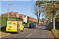
7
Filling Station and Tesco Express, Twyford Road
North of Albert Road.
Image: © Peter Facey
Taken: 28 Oct 2008
0.09 miles
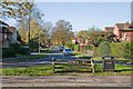
8
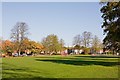
Recreation Ground and Children's Play Area, Lawn Road
The northern half of a long thin rectangular area between St Lawrence Road (on the west) and Lawn Road (on the east).
Image: © Peter Facey
Taken: 28 Oct 2008
0.10 miles
9
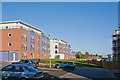
Flats in Alexander Square
The newly built (and being built) flats replace some small houses along Twyford Road which is runs along the other side of the buildings at left. (coordinates subject to revision when OS mapping available)
Image: © Peter Facey
Taken: 28 Oct 2008
0.10 miles
10
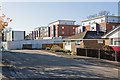
Flats in Alexander Square
Seen from Elizabeth Way. Those to the right had recently been completed whereas those to the left were still being built.
Image: © Peter Facey
Taken: 28 Oct 2008
0.10 miles