IMAGES TAKEN NEAR TO
Shakespeare Road, EASTLEIGH, SO50 4FP
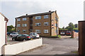
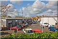
Introduction
This page details the photographs taken nearby to Shakespeare Road, SO50 4FP by members of the Geograph project.
The Geograph project started in 2005 with the aim of publishing, organising and preserving representative images for every square kilometre of Great Britain, Ireland and the Isle of Man.

There are currently over 7.5m images from over14,400 individuals and you can help contribute to the project by visiting https://www.geograph.org.uk
Image Map
Images are licensed for reuse under creativecommons.org/licenses/by-sa/2.0
Notes
- Clicking on the map will re-center to the selected point.
- The higher the marker number, the further away the image location is from the centre of the postcode.
Image Listing (114 Images Found)
Images are licensed for reuse under creativecommons.org/licenses/by-sa/2.0
Image
Details
Distance
1
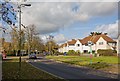
Shakespeare Road
Opposite Stratford Place.
Image: © Peter Facey
Taken: 28 Oct 2008
0.02 miles
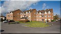
2
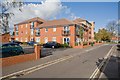
Rossetti Court, Byron Road
Looking along Byron Road towards its junction with Shakespeare Road. The recently built housing development on the left occupies a former commercial site.
Image: © Peter Facey
Taken: 28 Oct 2008
0.04 miles
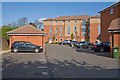
3
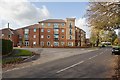
Rossetti Court, Shakespeare Road
The road in foreground is Shakespeare Road and that at left is Byron Road. This recent housing development occupies a former commercial site.
Image: © Peter Facey
Taken: 28 Oct 2008
0.05 miles
4
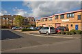
Shakespeare Business Centre, Hathaway Close
Housing in left distance is in Stratford Place.
Image: © Peter Facey
Taken: 28 Oct 2008
0.05 miles
5
Housing in Byron Road
The railway line is behind the camera.
Image: © Peter Facey
Taken: 28 Oct 2008
0.06 miles
6
Rossetti Court, Byron Road
Rear view of this recent development which occupies a former commercial site.
Image: © Peter Facey
Taken: 28 Oct 2008
0.06 miles
7
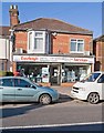
Eastleigh Services shop in Twyford Road
Image: © Peter Facey
Taken: 28 Oct 2008
0.08 miles
8
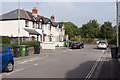
Salisbury Close
Running from The Crescent up to the railway line.
Image: © Peter Facey
Taken: 25 Sep 2013
0.08 miles
9
Salisbury Court, Salisbury Close
This Close runs right to left up to the railway line. Salisbury Court is presumably council flats.
Image: © Peter Facey
Taken: 25 Sep 2013
0.08 miles
10
Shakespeare Business Centre, Hathaway Close
Looking down on it from Twyford Road which is raised here to go over the railway line.
Image: © Peter Facey
Taken: 28 Oct 2008
0.09 miles