IMAGES TAKEN NEAR TO
Beale Crescent, EASTLEIGH, SO50 4DE
Introduction
This page details the photographs taken nearby to Beale Crescent, SO50 4DE by members of the Geograph project.
The Geograph project started in 2005 with the aim of publishing, organising and preserving representative images for every square kilometre of Great Britain, Ireland and the Isle of Man.

There are currently over 7.5m images from over14,400 individuals and you can help contribute to the project by visiting https://www.geograph.org.uk
Image Map
Images are licensed for reuse under creativecommons.org/licenses/by-sa/2.0
Notes
- Clicking on the map will re-center to the selected point.
- The higher the marker number, the further away the image location is from the centre of the postcode.
Image Listing (50 Images Found)
Images are licensed for reuse under creativecommons.org/licenses/by-sa/2.0
Image
Details
Distance
1
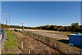
Development at Allbrook Farm
This is the field behind Image Pitmore Road is on the left, and the new access road to development curves towards the blue shed.
Image: © Peter Facey
Taken: 14 Oct 2012
0.02 miles
2
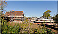
Development at Allbrook Farm
Image had been boarded up for more than ten years. Now it is being developed by Bargate. Their notice reads "A stunning development comprising one Grade II listed farmhouse, six 3-bedroom homes and one 4-bedroom home".
Image: © Peter Facey
Taken: 14 Oct 2012
0.06 miles
3
Development at Allbrook Farm
The farm house had been boarded up for at least ten years. It is now being redeveloped by Bargate and other houses are being built in the field behind it.
Image: © Peter Facey
Taken: 14 Oct 2012
0.06 miles
4
Remains of Allbrook Lock, Itchen Navigation
See Image
Image: © Dr Neil Clifton
Taken: 20 Aug 1996
0.07 miles
5
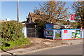
Development at Allbrook Farm
After more than ten years boarded up, Image is at last being redeveloped. The colourfully painted but rusty railway bridge is seen beyond.
Image: © Peter Facey
Taken: 14 Oct 2012
0.08 miles

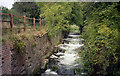
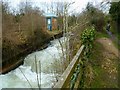
7
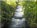
Itchen Navigation: Former Allbrook Lock
The original lock chamber on the defunct canal has been replaced by a series of baffles to create a succession of 5 weirs that bring the water down from the original level above the lock. This quite spectacular sight is hidden away, but is visible by walking along the B3335 Highbridge Road.
There are several photographs on the Geograph site of this lock in earlier times:-
1996: Image
2001: Image
2011: Image
2013: Image
Image: © Nigel Cox
Taken: 20 Sep 2013
0.08 miles
8
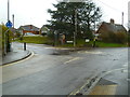
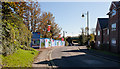
Mini roundabout in Allbrook
This is at the junction of Pitmore Road and Allbrook Hill.
Image: © Shazz
Taken: 18 Mar 2013
0.09 miles
9
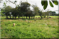
Sheep at Springbridge Farm
Viewed from the Itchen Way. I think they are supposed to be in the field behind the trees but a few have got into the scrubby land in the foreground.
Image: © Bill Boaden
Taken: 3 Sep 2021
0.09 miles
10
Itchen Way (75)
The Way passes the site of the Allbrook Lock.
Image: © Shazz
Taken: 18 Mar 2013
0.09 miles