IMAGES TAKEN NEAR TO
Challenger Place, SOUTHAMPTON, SO45 5SZ
Introduction
This page details the photographs taken nearby to Challenger Place, SO45 5SZ by members of the Geograph project.
The Geograph project started in 2005 with the aim of publishing, organising and preserving representative images for every square kilometre of Great Britain, Ireland and the Isle of Man.

There are currently over 7.5m images from over14,400 individuals and you can help contribute to the project by visiting https://www.geograph.org.uk
Image Map
Images are licensed for reuse under creativecommons.org/licenses/by-sa/2.0
Notes
- Clicking on the map will re-center to the selected point.
- The higher the marker number, the further away the image location is from the centre of the postcode.
Image Listing (5 Images Found)
Images are licensed for reuse under creativecommons.org/licenses/by-sa/2.0
Image
Details
Distance
1
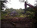
The Orchard being pulled down to make way for Flats
Image: © julian benn
Taken: 5 Oct 2006
0.08 miles
2
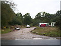
The Methodist Church site on Challenger Way
I took this photo just as the bulldozers moved to build the new Barratt / shared ownership estate
Image: © julian benn
Taken: 5 Oct 2006
0.08 miles
3
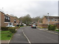
Cambria Drive, Dibden
A residential area
Image: © Alex McGregor
Taken: 30 Mar 2010
0.11 miles
4
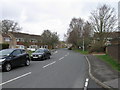
Cumberland Way, Dibden
Viewed from Cheviot Drive
Image: © Alex McGregor
Taken: 30 Mar 2010
0.17 miles
5
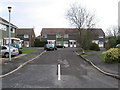
Cheviot Drive, Dibden
Residential area
Image: © Alex McGregor
Taken: 30 Mar 2010
0.21 miles