IMAGES TAKEN NEAR TO
West Road, SOUTHAMPTON, SO45 4RH
Introduction
This page details the photographs taken nearby to West Road, SO45 4RH by members of the Geograph project.
The Geograph project started in 2005 with the aim of publishing, organising and preserving representative images for every square kilometre of Great Britain, Ireland and the Isle of Man.

There are currently over 7.5m images from over14,400 individuals and you can help contribute to the project by visiting https://www.geograph.org.uk
Image Map
Images are licensed for reuse under creativecommons.org/licenses/by-sa/2.0
Notes
- Clicking on the map will re-center to the selected point.
- The higher the marker number, the further away the image location is from the centre of the postcode.
Image Listing (25 Images Found)
Images are licensed for reuse under creativecommons.org/licenses/by-sa/2.0
Image
Details
Distance
2
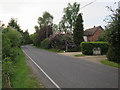
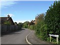
Roman Road
This leafy lane provides access to several residential areas and is separated from the Hythe by-pass by the bushes on the left.
Image: © David Martin
Taken: 29 May 2013
0.15 miles
5
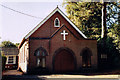
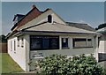
Dibden Purlieu Methodist Church
Built in 1922.
Image: © Michael FORD
Taken: Unknown
0.18 miles
6
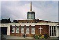
St Andrew, Dibden Purlieu
Built in 1970 as a Mission Church.
Image: © Michael FORD
Taken: Unknown
0.18 miles
7
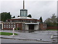
St Andrew's Parish Church, Dibden Purlieu, Hants
Image: © Rosemary Nelson
Taken: 6 Nov 2005
0.19 miles
8
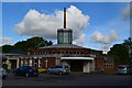
St Andrew's Parish Church, Dibden Purlieu
Image: © David Martin
Taken: 29 May 2013
0.19 miles
10
Former Dibden Purlieu Mission Hall
Erected in 1896. The building is now part of St Andrew's Church Centre and is used as a coffee shop.
Image: © Michael FORD
Taken: Unknown
0.20 miles