IMAGES TAKEN NEAR TO
May Crescent, SOUTHAMPTON, SO45 2GS
Introduction
This page details the photographs taken nearby to May Crescent, SO45 2GS by members of the Geograph project.
The Geograph project started in 2005 with the aim of publishing, organising and preserving representative images for every square kilometre of Great Britain, Ireland and the Isle of Man.

There are currently over 7.5m images from over14,400 individuals and you can help contribute to the project by visiting https://www.geograph.org.uk
Image Map
Images are licensed for reuse under creativecommons.org/licenses/by-sa/2.0
Notes
- Clicking on the map will re-center to the selected point.
- The higher the marker number, the further away the image location is from the centre of the postcode.
Image Listing (12 Images Found)
Images are licensed for reuse under creativecommons.org/licenses/by-sa/2.0
Image
Details
Distance
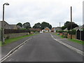
1
Rollestone Road
The brick pillar box on the left has a distinct lean towards the road!
Image: © David Martin
Taken: 31 Oct 2021
0.15 miles
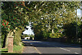
2
Holbury: postbox № SO45 647, Rollestone Road
Looking west along Rollestone Road towards Beaulieu, past this George VI-reign postbox which is emptied at 4:45pm on weekdays and at 8:30am on Saturdays.
Image: © Chris Downer
Taken: 17 May 2009
0.15 miles
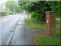
3
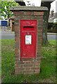
George VI postbox on Rollestone Road, Holbury
Postbox No. SO45 647.
Image: © JThomas
Taken: 28 Apr 2022
0.15 miles
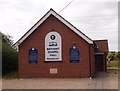
4
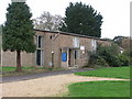
Good Shepherd Church, Holbury, Hants
Image: © Rosemary Nelson
Taken: 29 Oct 2005
0.15 miles
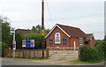
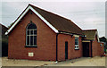
5
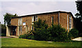
The Good Shepherd, Holbury
Modern brick building.
Image: © Michael FORD
Taken: Unknown
0.16 miles