IMAGES TAKEN NEAR TO
Ower Lane, SOUTHAMPTON, SO45 1BD
Introduction
This page details the photographs taken nearby to Ower Lane, SO45 1BD by members of the Geograph project.
The Geograph project started in 2005 with the aim of publishing, organising and preserving representative images for every square kilometre of Great Britain, Ireland and the Isle of Man.

There are currently over 7.5m images from over14,400 individuals and you can help contribute to the project by visiting https://www.geograph.org.uk
Image Map
Images are licensed for reuse under creativecommons.org/licenses/by-sa/2.0
Notes
- Clicking on the map will re-center to the selected point.
- The higher the marker number, the further away the image location is from the centre of the postcode.
Image Listing (71 Images Found)
Images are licensed for reuse under creativecommons.org/licenses/by-sa/2.0
Image
Details
Distance
1
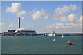
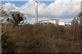
Fawley Power station
Viewbag from a ferry
Image: © Chris Allen
Taken: 23 Sep 2006
0.05 miles
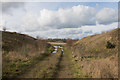
2
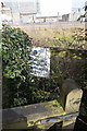
Footpath ends at boundary of Fawley Power Station
The notice reads
NATIONAL POWER PROPERTY
NO PUBLICRIGHT
OF WAY
Image: © Peter Facey
Taken: 16 Feb 2017
0.05 miles
3
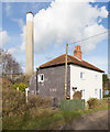
House at 1 Ower Lane
With the chimney of Fawley Power Station in the background (it seems near but is actually 275 metres beyond).
Image: © Peter Facey
Taken: 16 Feb 2017
0.05 miles
4

House at 1 Ower Lane
With Fawley Power Station in the background (it seems close but is actually 324 metres beyond the house).
Image: © Peter Facey
Taken: 16 Feb 2017
0.05 miles
5
Ower
Ower Farm, somewhat overshadowed.
Image: © Pierre Terre
Taken: 10 Feb 2008
0.07 miles
6
Fawley Power Station
Seen from footpath at Calshot.
Image: © Peter Facey
Taken: 16 Feb 2017
0.11 miles
7
Part of Fawley Quarry
Seen from Ower Lane.
Image: © Peter Facey
Taken: 16 Feb 2017
0.11 miles
8
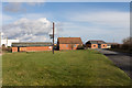
Buildings at Ower Farm
Beside the B3053. The left one had a sign on it for Cooper occupational therapy services (but their web site was not operational); whether this is connected with the building I know not.
Image: © Peter Facey
Taken: 16 Feb 2017
0.11 miles
9
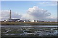
View across Calshot Marshes to Fawley Power Station.
Such a huge building looks quite small from this distance.
Image: © Jonathan Billinger
Taken: 2 Dec 2003
0.11 miles
10
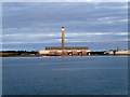
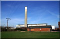
Southampton Water, Fawley Power Station (disused)
Fawley Power Station was an oil-fired power station on the western side of Southampton Water, between the villages of Fawley and Calshot. It was built by for the CEGB and was commissioned in 1971. Its 650 feet-high chimney is a prominent (and navigationally useful) landmark,
The station, which in its final years was owned and operated by npower, was oil-fired, powered by heavy fuel oil. A pipeline connected the station to the nearby Fawley oil refinery. The power station was closed on 31 March 2013. The decommissioning and demolition of the plant is expected to take several years, and the future of the site remains undecided (http://www.bbc.co.uk/news/uk-england-hampshire-21957458 BBC News).
Image: © David Dixon
Taken: 16 Jul 2016
0.12 miles