IMAGES TAKEN NEAR TO
Empress Road, LYNDHURST, SO43 7AE
Introduction
This page details the photographs taken nearby to Empress Road, SO43 7AE by members of the Geograph project.
The Geograph project started in 2005 with the aim of publishing, organising and preserving representative images for every square kilometre of Great Britain, Ireland and the Isle of Man.

There are currently over 7.5m images from over14,400 individuals and you can help contribute to the project by visiting https://www.geograph.org.uk
Image Map
Images are licensed for reuse under creativecommons.org/licenses/by-sa/2.0
Notes
- Clicking on the map will re-center to the selected point.
- The higher the marker number, the further away the image location is from the centre of the postcode.
Image Listing (434 Images Found)
Images are licensed for reuse under creativecommons.org/licenses/by-sa/2.0
Image
Details
Distance
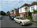
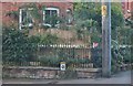
2
Looking from Romsey Road into Empress Road
Image: © Basher Eyre
Taken: 24 Sep 2011
0.03 miles
3
Bottom end of Empress Road
Unusually I have partially obscured the post box- demerits all round!
Image: © Basher Eyre
Taken: 24 Sep 2011
0.03 miles
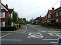
6

Petrol Station on Queen's Parade, Lyndhurst
Image: © David Howard
Taken: 7 Sep 2019
0.04 miles
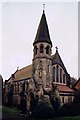
7
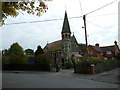
Our Lady of the Assumption RC Church, Empress Road
Image: © Basher Eyre
Taken: 24 Sep 2011
0.04 miles
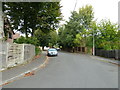
9
Looking along Empress Road towards Romsey Road
Image: © Basher Eyre
Taken: 24 Sep 2011
0.04 miles
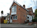
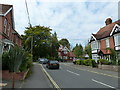
10
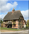
Sweet old house, Romsey Road, Lyndhurst
I walked all round this but could not see a house name.
Image: © Peter Facey
Taken: 12 Apr 2006
0.05 miles