IMAGES TAKEN NEAR TO
SO4 2EE
Introduction
This page details the photographs taken nearby to SO4 2EE by members of the Geograph project.
The Geograph project started in 2005 with the aim of publishing, organising and preserving representative images for every square kilometre of Great Britain, Ireland and the Isle of Man.

There are currently over 7.5m images from over14,400 individuals and you can help contribute to the project by visiting https://www.geograph.org.uk
Image Map
Images are licensed for reuse under creativecommons.org/licenses/by-sa/2.0
Notes
- Clicking on the map will re-center to the selected point.
- The higher the marker number, the further away the image location is from the centre of the postcode.
Image Listing (12 Images Found)
Images are licensed for reuse under creativecommons.org/licenses/by-sa/2.0
Image
Details
Distance
1
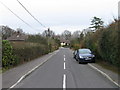
Whartons Close, Ashurst
Viewed from Whartons Lane
Image: © Alex McGregor
Taken: 22 Mar 2010
0.03 miles
3
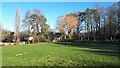
Morning sunlight on playing field, Ashurst
Seen from near the gate to Lakewood Road.
Image: © David Martin
Taken: 6 Feb 2023
0.09 miles
4
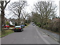
Whartons Lane, Ashurst
Viewed from Whartons Close
Image: © Alex McGregor
Taken: 22 Mar 2010
0.10 miles
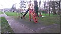
5
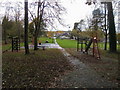
Playground by Whartons Lane
Playground by Whartons Lane looking across to Lakewood Road
Image: © Shaun Ferguson
Taken: 7 Nov 2008
0.12 miles
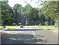
7
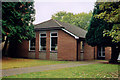
St Joseph, Ashurst
A newish building in an older complex.
Image: © Michael FORD
Taken: Unknown
0.22 miles
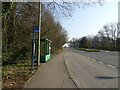
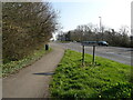
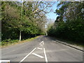
10
Deerleap Lane junction with A35
The busy Southampton to Lyndhurst main road is a formidable obstacle.
Image: © Stuart Logan
Taken: 22 Aug 2012
0.24 miles