IMAGES TAKEN NEAR TO
Armstrong Lane, BROCKENHURST, SO42 7SY
Introduction
This page details the photographs taken nearby to Armstrong Lane, SO42 7SY by members of the Geograph project.
The Geograph project started in 2005 with the aim of publishing, organising and preserving representative images for every square kilometre of Great Britain, Ireland and the Isle of Man.

There are currently over 7.5m images from over14,400 individuals and you can help contribute to the project by visiting https://www.geograph.org.uk
Image Map
Images are licensed for reuse under creativecommons.org/licenses/by-sa/2.0
Notes
- Clicking on the map will re-center to the selected point.
- The higher the marker number, the further away the image location is from the centre of the postcode.
Image Listing (37 Images Found)
Images are licensed for reuse under creativecommons.org/licenses/by-sa/2.0
Image
Details
Distance
1
Broadlands Road, Brockenhurst
A private road which is also a public footpath. The road affords access to up market houses on either side.
Image: © Peter Facey
Taken: 7 Jun 2006
0.09 miles
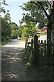
2
Cottage on the access road to the North Weirs
The access road also provides a popular cycle route out of Brockenhurst.
Image: © Trevor Harris
Taken: 29 May 2009
0.12 miles
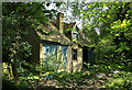
3
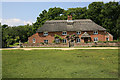
The Thatched Cottage, North Weirs, Brockenhurst
North Weirs is the gravel track shown. The cottage is imaginatively named. The Forest comes up to the track.
The thatch caught fire on 3rd December 2013 http://www.bbc.co.uk/news/uk-england-hampshire-25200655 and http://m.dailyecho.co.uk/news/10850700.Investigation_after_90_firefighters_tackle_major_house_blaze/
Later http://www.geograph.org.uk/photo/3768846
Image: © Peter Facey
Taken: 7 Jun 2006
0.13 miles
4
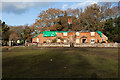
The Thatched Cottage, North Weirs, Brockenhurst
After the fire on 3rd December 2013. Earlier http://www.geograph.org.uk/photo/183646
Image: © Peter Facey
Taken: 6 Dec 2013
0.13 miles
5
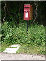
Brockenhurst: postbox № SO42 12, Armstrong Close
A standard lamp-box mounted on a metal pole with a couple of paving slabs thoughtfully providing easy access.
Image: © Chris Downer
Taken: 13 Jul 2014
0.15 miles
6
Semi-derelict store, Forest View, Brockenhurst
This building - rather more than a shed, less than a house - seems to be in the corner of the garden of a property in Forest View, but seen from a footpath. Not shown on my 1996 1:25000 OS map.
Image: © Peter Facey
Taken: 7 Jun 2006
0.15 miles
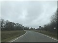
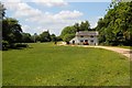
9
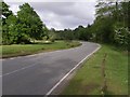
Burley Road, Brockenhurst, New Forest
This is Burley Road leading in to Brockenhurst, with Culverley Green on the right. The turning just up the road on the left is Armstrong Road.
Image: © Jim Champion
Taken: 12 May 2007
0.19 miles
10
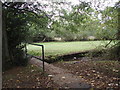
Footbridge over stream at Pounds Farm
Taken on the very northern boundary of the square
Image: © Basher Eyre
Taken: 13 Oct 2007
0.20 miles