IMAGES TAKEN NEAR TO
Forest Park Road, BROCKENHURST, SO42 7SW
Introduction
This page details the photographs taken nearby to Forest Park Road, SO42 7SW by members of the Geograph project.
The Geograph project started in 2005 with the aim of publishing, organising and preserving representative images for every square kilometre of Great Britain, Ireland and the Isle of Man.

There are currently over 7.5m images from over14,400 individuals and you can help contribute to the project by visiting https://www.geograph.org.uk
Image Map
Images are licensed for reuse under creativecommons.org/licenses/by-sa/2.0
Notes
- Clicking on the map will re-center to the selected point.
- The higher the marker number, the further away the image location is from the centre of the postcode.
Image Listing (14 Images Found)
Images are licensed for reuse under creativecommons.org/licenses/by-sa/2.0
Image
Details
Distance
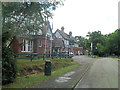
2
Brockenhurst, Forest Park Hotel
3-star hotel on Rhinefield Road: http://www.forestdalehotels.com/Hotels/Southern-England/Forest-Park-Hotel,-Brockenhurst
Image: © Mike Faherty
Taken: 13 Nov 2012
0.07 miles
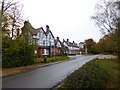
3
Forest Park Hotel, Rhinefield Road, Brockenhurst
The grounds of the hotel occupy the whole of the crescent-shaped area formed by Forest Park Road.
Image: © Peter Facey
Taken: 7 Jun 2006
0.08 miles
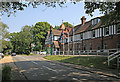
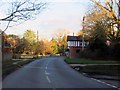
4
Western end of Forest Park Road seen from Rhinefield Road, Brockenhurst
Road sign glimpsed in middle distance is for Knowle Road which is a turning on the right. Forest Park Road is a private road to residential housing.
Image: © Peter Facey
Taken: 7 Jun 2006
0.09 miles
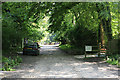
5
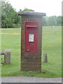
Brockenhurst: postbox № SO42 180, Broadlands Road
An Elizabeth II-reign postbox at the start of this gravel road which is private, as made plain by the signs attached to the brick pillar. It is, however, a public footpath.
Image: © Chris Downer
Taken: 13 Jul 2014
0.13 miles
7
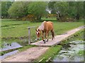
Pony on a footbridge, Butts Lawn, New Forest
A number of drains cross Butts Lawn, an area popular with ponies. This small footbridge is on the path from the Meerut Road/Burley Road junction to the allotment gardens.
Image: © Jim Champion
Taken: 20 May 2006
0.15 miles
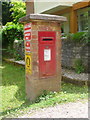
9
Brockenhurst: postbox № SO42 60, Rhinefield Road
This Elizabeth II-reign postbox is set into a brick pillar on the corner of Meerut Road, where the town abruptly becomes a typical, rural New Forest scene.
Image: © Chris Downer
Taken: 13 Jul 2014
0.19 miles
10
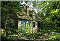
Semi-derelict store, Forest View, Brockenhurst
This building - rather more than a shed, less than a house - seems to be in the corner of the garden of a property in Forest View, but seen from a footpath. Not shown on my 1996 1:25000 OS map.
Image: © Peter Facey
Taken: 7 Jun 2006
0.21 miles