IMAGES TAKEN NEAR TO
School Road, SOUTHAMPTON, SO40 9HZ
Introduction
This page details the photographs taken nearby to School Road, SO40 9HZ by members of the Geograph project.
The Geograph project started in 2005 with the aim of publishing, organising and preserving representative images for every square kilometre of Great Britain, Ireland and the Isle of Man.

There are currently over 7.5m images from over14,400 individuals and you can help contribute to the project by visiting https://www.geograph.org.uk
Image Map
Images are licensed for reuse under creativecommons.org/licenses/by-sa/2.0
Notes
- Clicking on the map will re-center to the selected point.
- The higher the marker number, the further away the image location is from the centre of the postcode.
Image Listing (166 Images Found)
Images are licensed for reuse under creativecommons.org/licenses/by-sa/2.0
Image
Details
Distance
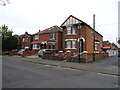
1
Totton Masonic Hall
On Luxby Road, Eling. http://www.masonicmeetings.info/venue06330.php
Image: © Mike Faherty
Taken: 27 Jun 2012
0.10 miles
6
A35 footbridge beyond Bartram Road junction
Image: © Colin Pyle
Taken: 25 Oct 2014
0.13 miles
9
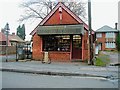
Sweet Shop, Eling Lane
This shop is built on the site of the old Eling village smithy. Local folklore has it that the arrow which killed William Rufus (King William II) was made here. Image
Image: © John Lucas
Taken: 21 Jan 2002
0.15 miles
