IMAGES TAKEN NEAR TO
Mussett Close, SOUTHAMPTON, SO40 8XD
Introduction
This page details the photographs taken nearby to Mussett Close, SO40 8XD by members of the Geograph project.
The Geograph project started in 2005 with the aim of publishing, organising and preserving representative images for every square kilometre of Great Britain, Ireland and the Isle of Man.

There are currently over 7.5m images from over14,400 individuals and you can help contribute to the project by visiting https://www.geograph.org.uk
Image Map
Images are licensed for reuse under creativecommons.org/licenses/by-sa/2.0
Notes
- Clicking on the map will re-center to the selected point.
- The higher the marker number, the further away the image location is from the centre of the postcode.
Image Listing (67 Images Found)
Images are licensed for reuse under creativecommons.org/licenses/by-sa/2.0
Image
Details
Distance
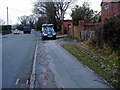
2
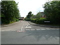
Looking from Water Lane into Lawford Way
Image: © Basher Eyre
Taken: 29 Jun 2011
0.02 miles
3
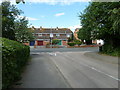
Looking from Lawford Way into Water Lane
Image: © Basher Eyre
Taken: 29 Jun 2011
0.02 miles
4
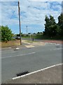
Looking from Hammond Way into Water Lane
Image: © Basher Eyre
Taken: 29 Jun 2011
0.03 miles
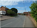
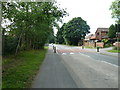
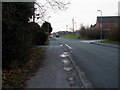
6
Water Lane, Totton
Looking in the direction of Hammonds Green
Image: © John Lucas
Taken: 21 Jan 2002
0.05 miles
7
Water Lane, Totton
Looking in the direction of Totton
Image: © John Lucas
Taken: 21 Jan 2002
0.05 miles