IMAGES TAKEN NEAR TO
Broadmeadow Close, SOUTHAMPTON, SO40 8WB
Introduction
This page details the photographs taken nearby to Broadmeadow Close, SO40 8WB by members of the Geograph project.
The Geograph project started in 2005 with the aim of publishing, organising and preserving representative images for every square kilometre of Great Britain, Ireland and the Isle of Man.

There are currently over 7.5m images from over14,400 individuals and you can help contribute to the project by visiting https://www.geograph.org.uk
Image Map
Images are licensed for reuse under creativecommons.org/licenses/by-sa/2.0
Notes
- Clicking on the map will re-center to the selected point.
- The higher the marker number, the further away the image location is from the centre of the postcode.
Image Listing (47 Images Found)
Images are licensed for reuse under creativecommons.org/licenses/by-sa/2.0
Image
Details
Distance
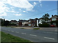
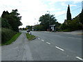
1
Looking from Ringwood Road into Broadmeadow Close
Image: © Basher Eyre
Taken: 29 Jun 2011
0.03 miles
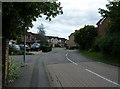
2

Looking from Broadmeadow Close into Ringwood Road
Image: © Basher Eyre
Taken: 29 Jun 2011
0.06 miles
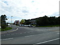
3
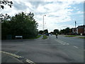
Junction of Broadmeadow Close and Ringwood Road
Image: © Basher Eyre
Taken: 29 Jun 2011
0.06 miles
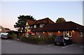
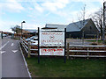
4
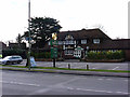
The Old Farmhouse Pub Ringwood Road Totton
Image: © John Lucas
Taken: 12 Mar 2013
0.07 miles
6
Looking from Ringwood Road into Southern Gardens
Image: © Basher Eyre
Taken: 29 Jun 2011
0.09 miles
7
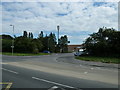
Approaching the junction of Ringwood Road and Southern Gardens
Image: © Basher Eyre
Taken: 29 Jun 2011
0.10 miles
9
Entrance to Abbotswood School Totton
Originally called Ringwood Road School, the name was changed in the 1950s.
Image: © John Lucas
Taken: 12 Mar 2013
0.10 miles