IMAGES TAKEN NEAR TO
Shaw Close, SOUTHAMPTON, SO40 8TS
Introduction
This page details the photographs taken nearby to Shaw Close, SO40 8TS by members of the Geograph project.
The Geograph project started in 2005 with the aim of publishing, organising and preserving representative images for every square kilometre of Great Britain, Ireland and the Isle of Man.

There are currently over 7.5m images from over14,400 individuals and you can help contribute to the project by visiting https://www.geograph.org.uk
Image Map
Images are licensed for reuse under creativecommons.org/licenses/by-sa/2.0
Notes
- Clicking on the map will re-center to the selected point.
- The higher the marker number, the further away the image location is from the centre of the postcode.
Image Listing (48 Images Found)
Images are licensed for reuse under creativecommons.org/licenses/by-sa/2.0
Image
Details
Distance
2
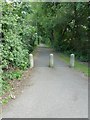
Path running due south from Ringwood Road
Image: © Basher Eyre
Taken: 29 Jun 2011
0.05 miles
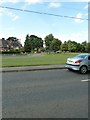
3

Looking across a green towards Ashby Road
Image: © Basher Eyre
Taken: 29 Jun 2011
0.06 miles


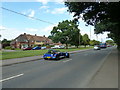
9

Looking from Calmore Road into Ringwood Road
Image: © Basher Eyre
Taken: 29 Jun 2011
0.12 miles
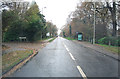
10
Looking across Ringwood Road to a green
Image: © Basher Eyre
Taken: 29 Jun 2011
0.13 miles