IMAGES TAKEN NEAR TO
Main Road, SOUTHAMPTON, SO40 7ES
Introduction
This page details the photographs taken nearby to Main Road, SO40 7ES by members of the Geograph project.
The Geograph project started in 2005 with the aim of publishing, organising and preserving representative images for every square kilometre of Great Britain, Ireland and the Isle of Man.

There are currently over 7.5m images from over14,400 individuals and you can help contribute to the project by visiting https://www.geograph.org.uk
Image Map
Images are licensed for reuse under creativecommons.org/licenses/by-sa/2.0
Notes
- Clicking on the map will re-center to the selected point.
- The higher the marker number, the further away the image location is from the centre of the postcode.
Image Listing (21 Images Found)
Images are licensed for reuse under creativecommons.org/licenses/by-sa/2.0
Image
Details
Distance
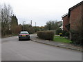
1
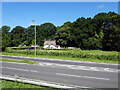
A typical New Forest cottage
Beside Main Road, Hounsdown.
Image: © John Lucas
Taken: 14 Jul 2021
0.03 miles
3
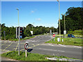
Road junction at Hounsdown
The A35 crossing an A326 spur road.
Image: © John Lucas
Taken: 14 Jul 2021
0.07 miles
4
A326 from under the A35 at Hounsdown junction
Image: © Colin Pyle
Taken: 25 Oct 2014
0.09 miles
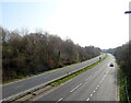
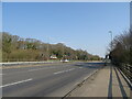
6
A35 Main Road
Approaching the roundabout at the split level intersection with the A326.
Image: © Robin Webster
Taken: 13 Nov 2022
0.14 miles
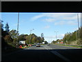
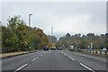
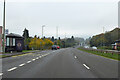
7
A35 at Hounsdown junction
Heading west entering Colbury
Image: © John Firth
Taken: 3 Apr 2014
0.14 miles

9
Jacobs Walk, Hounsdown
A residential area of Totton
Image: © Alex McGregor
Taken: 22 Mar 2010
0.17 miles
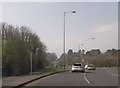
10
A35 Main Road, Hounsdown
Heading west.
Image: © Robin Webster
Taken: 13 Nov 2022
0.19 miles