IMAGES TAKEN NEAR TO
Portside Close, SOUTHAMPTON, SO40 4AL
Introduction
This page details the photographs taken nearby to Portside Close, SO40 4AL by members of the Geograph project.
The Geograph project started in 2005 with the aim of publishing, organising and preserving representative images for every square kilometre of Great Britain, Ireland and the Isle of Man.

There are currently over 7.5m images from over14,400 individuals and you can help contribute to the project by visiting https://www.geograph.org.uk
Image Map (Loading...)


Getting Data...Please wait
Leaflet Map data © OpenStreetMap
Images are licensed for reuse under creativecommons.org/licenses/by-sa/2.0
Notes
- Clicking on the map will re-center to the selected point.
- The higher the marker number, the further away the image location is from the centre of the postcode.
Image Listing (45 Images Found)
Images are licensed for reuse under creativecommons.org/licenses/by-sa/2.0
Image
Details
Distance
1
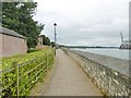
Marchwood, path
Along the northern boundary of the former RNAD site; right, River Test, with a crane at Southampton Docks.
Image: © Mike Faherty
Taken: 16 Jul 2017
0.05 miles
2
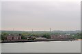
Apartments and Houses on the site of the former Royal Naval Armaments Depot, Marchwood, Southampton
These 'new' buildings date from the early 1990s and have a commanding view over
the River Test … mainly of the Container Port … but you can't have everything.
Sadly, not much is left of the former Royal Naval Armaments Depot at Marchwood,
which was opened in 1815 … as we know, an important year in British History.
It was built as a satellite depot, to the main depot at Gosport, for the bulk
storage of Barrels of Gunpowder … some 21,000 were stored at this site.
The site was chosen as it had good land and river access but was a
suitable distance away from the Naval Dockyards in case of explosion.
Eventually the site became redundant and in the early 1950s an Oil Fuelled
Power Station was built and opened on part of the site. This lasted until the
1980s and has now been replaced by the new Marchwood Power Station … see …
Image
Image: © Terry Robinson
Taken: 20 May 2013
0.07 miles
4
Marchwood, hard & slipway
Formerly military, now used by http://www.marchwoodyc.org.uk/mycxtra/mycx_aboutmyc_myctoday.php
Image: © Mike Faherty
Taken: 16 Jul 2017
0.08 miles
5
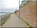
Marchwood, wall
Surrounding the northern boundary of the former RNAD site, this appears to be the Historic England-listed blast wall of the former magazine. http://www.imagesofengland.org.uk/Details/Default.aspx?id=143447&mode=adv
Image: © Mike Faherty
Taken: 16 Jul 2017
0.09 miles
6
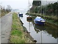
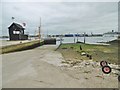
Creek Near Marchwood
A little lane between the houses and the industrial site that contains the incinerator at Marchwood leads to this outlet area. On the right is the incinerator and the left are houses and a yacht club. Straight across the water are the Southampton docks.
Image: © Gillian Thomas
Taken: 30 Mar 2007
0.10 miles
7

Early autumn at Marchwood
A tree-lined path within the former Royal Naval Armaments Depot, now redeveloped as housing.
Image: © David Martin
Taken: 11 Oct 2020
0.10 miles
8

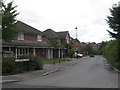
Marchwood, Ordnance Way
Suburban road and housing, on the former Royal Naval Armaments Depot site.
Image: © Mike Faherty
Taken: 16 Jul 2017
0.11 miles
9
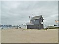
Marchwood, lookout tower
At the entrance to Marchwood Yacht Club. http://www.marchwoodyc.org.uk/mycxtra/mycx_aboutmyc_myctoday.php
Image: © Mike Faherty
Taken: 16 Jul 2017
0.11 miles
10
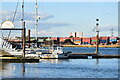
Marchwood Yacht Club, with Millbrook beyond
Image: © David Martin
Taken: 11 Oct 2020
0.12 miles