IMAGES TAKEN NEAR TO
Sylvia Crescent, SOUTHAMPTON, SO40 3LN
Introduction
This page details the photographs taken nearby to Sylvia Crescent, SO40 3LN by members of the Geograph project.
The Geograph project started in 2005 with the aim of publishing, organising and preserving representative images for every square kilometre of Great Britain, Ireland and the Isle of Man.

There are currently over 7.5m images from over14,400 individuals and you can help contribute to the project by visiting https://www.geograph.org.uk
Image Map
Images are licensed for reuse under creativecommons.org/licenses/by-sa/2.0
Notes
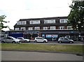
- Clicking on the map will re-center to the selected point.
- The higher the marker number, the further away the image location is from the centre of the postcode.
Image Listing (15 Images Found)
Images are licensed for reuse under creativecommons.org/licenses/by-sa/2.0
Image
Details
Distance
1
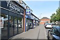
Parade of shops beside Salisbury Road, Testwood
A typical suburban cluster comprising (from nearest) a hairdresser, pharmacy, Chinese takeaway and convenience store, set back from the main road.
Image: © David Martin
Taken: 4 Oct 2023
0.07 miles
3
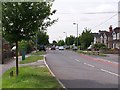
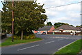
Salisbury Road, Testwood
Here at its southern end, the A36 has become a suburban street, although in the rush hour this is still a major route through the western outskirts of Southampton.
Image: © David Martin
Taken: 20 May 2008
0.09 miles
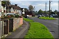
5
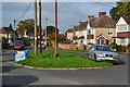
Traffic island at the end of Cheam Way
Image: © David Martin
Taken: 15 Oct 2017
0.11 miles
6
Junction of Sutton Road and Salisbury Road
Image: © David Martin
Taken: 15 Oct 2017
0.12 miles
7
Totton Kingdom Hall
At the end of Cheam Way.
Image: © Michael FORD
Taken: Unknown
0.14 miles
8
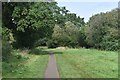
Path between playing fields at Testwood
Image: © David Martin
Taken: 4 Oct 2023
0.15 miles
9
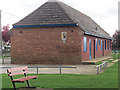
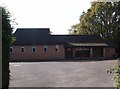
Sports amenity building
Situated in Testwood recreation Ground this unedifying modern building replaced the older wooden shed known as the 'reccy's hut'. In it the ground maintenance operative -reccy to us kids - kept his mowers, corner flags, and line marking machines. Presumably this utilitarian structure does the same job?
Image: © Stuart Logan
Taken: 3 Apr 2011
0.17 miles
10
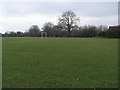
Testwood Playing Fields
Testwood Playing Field off Salisbury Road by The Redfords
Image: © Shaun Ferguson
Taken: 29 Jan 2009
0.17 miles